 Filter: Categories of Wisconsin Historical Images
Filter: Subject of Fields (Agriculture)
Filter: Subject of architecture
Filter: Subject of aerial photographs
Filter: Categories of Wisconsin Historical Images
Filter: Subject of Fields (Agriculture)
Filter: Subject of architecture
Filter: Subject of aerial photographs

| Date: | 1908 |
|---|---|
| Description: | Aerial view of Camp Randall Field on the University of Wisconsin-Madison campus. University Heights is in the background. |

| Date: | 1950 |
|---|---|
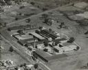
| Description: | Aerial view of the Frank Lloyd-Wright-dsigned Unitarian Church under construction and the Veteran's Administration Hospital, also under construction, to th... |
| Date: | 1947 |
|---|---|
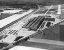
| Description: | Aerial view of International Harvester's Evansville Works factory complex. |
| Date: | 1947 |
|---|---|
| Description: | Aerial view of International Harvester's Evansville Works factory complex. The Evansville Works produced refrigerators, freezers and air conditioners. |

| Date: | 1905 |
|---|---|
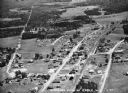
| Description: | Aerial view of town, with several large buildings along railroad tracks in the foreground, and fields and trees in the distance. Pedestrians are walking al... |

| Date: | 10 1928 |
|---|---|
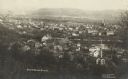
| Description: | Aerial view of Sun Prairie, including the central business district, residences, and the surrounding countryside stretching to the horizon. |

| Date: | 11 1951 |
|---|---|
| Description: | Aerial view of US Highway 14 southeast of La Crosse descending into Mormon Coulee. The original caption of the print, which is undated, describes the road ... |
| Date: | 1930 |
|---|---|
| Description: | Aerial view of International Harvester's St. Paul Flax Twine Mill. |

| Date: | 02 09 1949 |
|---|---|
| Description: | Three aerial views of the John Fluckiger farm and farm buildings amid snow-covered fields near Verona, operated by son Ivan Fluckiger. |

| Date: | 02 09 1949 |
|---|---|
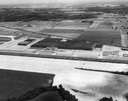
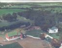
| Description: | One of four aerial views of the Edwin Blaney farm and farm buildings surrounded by snow-covered fields. Four miles south of Madison and a mile west of U.S.... |
| Date: | 04 27 1949 |
|---|---|
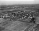
| Description: | Aerial view of the Veterans Hospital at Tomah. |

| Date: | 04 30 1949 |
|---|---|
| Description: | Aerial photograph of Blanchardville. |
| Date: | 1936 |
|---|---|
| Description: | Aerial view of Cable, in northern Wisconsin. Text at foot reads: "Airplane View of Cable, Wis. 244." |

| Date: | |
|---|---|
| Description: | Aerial view of Plymouth. Published by McLaughlin Aerial Surveys. |
| Date: | 07 29 1909 |
|---|---|
| Description: | Aerial view of the downtown area, including a bridge spanning the Trempealeau River. Caption reads: "View of Arcadia, Wisconsin." |

| Date: | 09 1996 |
|---|---|
| Description: | "Theresa's Bonduel & Wisconsin Streets from the air." |
| Date: | |
|---|---|
| Description: | Hand-tinted aerial photograph of the Apps Farm in the Wild Rose vicinity. |

| Date: | 1956 |
|---|---|
| Description: | Aerial view of residential homes, farmland and streets. |
If you didn't find the material you searched for, our Library Reference Staff can help.
Call our reference desk at 608-264-6535 or email us at:

