Filter: Categories of Wisconsin Historical Images
Filter: Subject of Fields (Agriculture)
Filter: Subject of bird's-eye views
Filter: Categories of Wisconsin Historical Images
Filter: Subject of Fields (Agriculture)
Filter: Subject of bird's-eye views

| Date: | 1874 |
|---|---|
| Description: | Bird's-eye map of Chippewa Falls. |

| Date: | 1878 |
|---|---|
| Description: | Bird's-eye map of Kewaskum. Includes a list of hotels, churches, post office, railroad depot, etc. |

| Date: | 1881 |
|---|---|
| Description: | Bird's-eye map of Milton Junction. |

| Date: | 1883 |
|---|---|
| Description: | Bird's-eye map of Sauk City. |

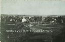
| Date: | 1871 |
|---|---|
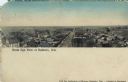
| Description: | Like many southeastern Wisconsin villages, Edgerton was settled by Yankee immigrants in the 1830s. Though this view gives no indication of it, by 1871 toba... |

| Date: | 1884 |
|---|---|
| Description: | Bird's-eye view drawing of the grounds of Villa Louis, the estate of the fur trading Dousman family. After the death of H. Louis Dousman's mother in 1882, ... |
| Date: | 1907 |
|---|---|
| Description: | Caption reads: "Birdseye [sic] View of Cameron Wisconsin." Railroad cars are on railroad tracks between buildings, and houses and what may be the hi... |

| Date: | 1905 |
|---|---|
| Description: | View across fields toward the town. Caption reads: "Birdseye[sic] view of Mauston, Wis." |
| Date: | 1930 |
|---|---|
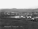
| Description: | View from hill of a farm near a pond. There are homes along the far shoreline, and a lake and hills in the far background. |

| Date: | 1921 |
|---|---|
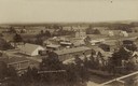
| Description: | Elevated view of Woodstock, with dwellings, farm buildings and a church. Pastures and fields surround the town. |

| Date: | |
|---|---|
| Description: | A bird's eye view overlooking the Mississippi River, sand bars, the railroad bridge, surrounding forests and wetlands. |

| Date: | 1908 |
|---|---|
| Description: | Elevated photographic postcard view of town showing homes and businesses. A windmill is in the foreground. The school is on the far edge of town on the lef... |
| Date: | 1908 |
|---|---|
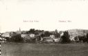
| Description: | Colorized panoramic elevated view with the main commercial district in the center. The high school is on the far right. Caption reads: "Birds [sic] Eye Vie... |
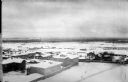
| Date: | 1918 |
|---|---|
| Description: | Elevated view of Archangel [Archangelsk], Russia. There are pedestrians on the snowy street below, including horses and sleighs. Buildings and dwellings li... |
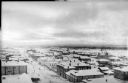
| Date: | 1918 |
|---|---|
| Description: | Elevated view of Archangel [Archangelsk], Russia. There are pedestrians on the snowy street below. Buildings and dwellings line the streets. In the backgro... |
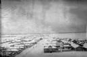
| Date: | 1918 |
|---|---|
| Description: | Elevated view of Archangel [Archangelsk], Russia, with buildings, dwellings and yards. Pedestrians are walking on the street below. In the distance are fie... |

| Date: | 1937 |
|---|---|
| Description: | Pictorial map showing historical events and locations within the state of Wisconsin, as well as waterways and counties. Original caption on the bottom marg... |
| Date: | 1912 |
|---|---|
| Description: | Elevated view of the town, with a church and dwellings, surrounded by fields. Caption reads: "Birds [sic] Eye View of Eureka, Wis." |
If you didn't find the material you searched for, our Library Reference Staff can help.
Call our reference desk at 608-264-6535 or email us at: