 Filter: Categories of Wisconsin Historical Images
Filter: Subject of Fields (Agriculture)
Filter: Subject of bridges
Filter: Subject of cities and towns
Filter: Categories of Wisconsin Historical Images
Filter: Subject of Fields (Agriculture)
Filter: Subject of bridges
Filter: Subject of cities and towns

| Date: | 01 1934 |
|---|---|
| Description: | Aerial view of New Butler, in Waukesha County. |

| Date: | 1874 |
|---|---|
| Description: | Bird's-eye map of Chippewa Falls. |

| Date: | 1883 |
|---|---|
| Description: | Bird's-eye map of Sauk City. |

| Date: | 1900 |
|---|---|
| Description: | Elevated view of the brewery dwarfed by the overhead bluffs. The brewery was built by William Schmitz. George Scheibl ran the brewery from 1899 until his d... |
| Date: | 1948 |
|---|---|
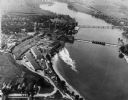
| Description: | Aerial view of the Kimberly-Clark Paper Mill on the Fox River, just east of Appleton. |
| Date: | 1922 |
|---|---|
| Description: | Elevated view of bridge over Wisconsin River built in 1921 to take the place of the old wooden bridge when it became condemned. Caption reads: "Prairie Du ... |
| Date: | 1920 |
|---|---|
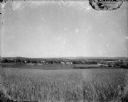
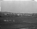
| Description: | A view of a rolling rural landscape, most likely in Sauk County. In the far distance are houses and farm buildings, a church and a larger building, center ... |
| Date: | 1900 |
|---|---|
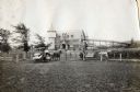
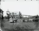
| Description: | Two men use horse-drawn McCormick grain binders in a field in front of a dairy barn at the University of Wisconsin-Madison. A grain elevator or walkway ext... |
| Date: | 1900 |
|---|---|
| Description: | Two men use horse-drawn McCormick grain binders in a field in front of a dairy barn at the University of Wisconsin-Madison. A grain elevator or walkway ext... |
| Date: | |
|---|---|
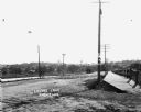
| Description: | View of Lovers Lane, which a dirt road with a sidewalk and bridge on the right. There are power lines in the foreground, and a town in the background. Ther... |

| Date: | |
|---|---|
| Description: | Colorized postcard of the horseshoe curve of railroad tracks. Elevated view of the railroad tracks with train snaking past a farmhouse and a bridge suspend... |
| Date: | 07 29 1909 |
|---|---|
| Description: | Aerial view of the downtown area, including a bridge spanning the Trempealeau River. Caption reads: "View of Arcadia, Wisconsin." |
| Date: | 05 22 1906 |
|---|---|
| Description: | Aerial view of the city and rolling hills in the background. A bridge crossing the Trempealeau River is also visible. |
| Date: | 1920 |
|---|---|
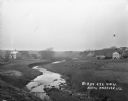
| Description: | View from low hill of a stream flowing through fields. There are cows in the pasture on the right. In the distance is a bridge, road, and buildings. |
| Date: | 1921 |
|---|---|
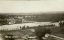
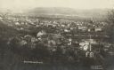
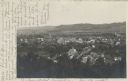
| Description: | Elevated view over farm fields in the foreground and town in the distance, with low rolling hills in the far background. Buildings that stand out are St Lu... |

| Date: | |
|---|---|
| Description: | View over river with a small bridge in front of the Carnation Factory with tree-covered hills in the background. Dwellings and fields are in the far right ... |

| Date: | 1926 |
|---|---|
| Description: | View from hill looking down at homes and businesses in town. A bridge goes over the Kickapoo River. The depot and railroad tracks and Main Street are behin... |
| Date: | 1908 |
|---|---|
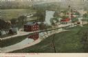
| Description: | Colorized postcard with an elevated view of the pumping station. On the left is a bridge over the river, and buildings on a strip of land between the river... |

| Date: | |
|---|---|
| Description: | Aerial view of harbors and bridge. Farm fields are on either side of the bridge. The city of Sturgeon Bay is in the distance. There are docks along the sho... |

| Date: | |
|---|---|
| Description: | Aerial view of harbor. In the foreground is a lighthouse and breakwaters. Bridges cross the harbor, and there are factory and industrial buildings near the... |
If you didn't find the material you searched for, our Library Reference Staff can help.
Call our reference desk at 608-264-6535 or email us at: