Visit our other Wisconsin Historical Society websites!
 Filter: Categories of Wisconsin Historical Images
Filter: Subject of Fields (Agriculture)
Filter: Subject of cities and towns
Filter: Categories of Wisconsin Historical Images
Filter: Subject of Fields (Agriculture)
Filter: Subject of cities and towns

| Date: | 1878 |
|---|---|
| Description: | Bird's-eye map of Kewaskum. Includes a list of hotels, churches, post office, railroad depot, etc. |

| Date: | 1881 |
|---|---|
| Description: | Bird's-eye map of Milton Junction. |
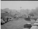
| Date: | 09 10 1945 |
|---|---|
| Description: | Elevated view of a Findorff truck and earthmover standing ready to excavate for an addition to the Red Dot Foods Incorporated potato chip factory, 1441 Eas... |
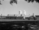
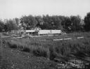
| Date: | 06 30 1944 |
|---|---|
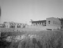
| Description: | Rennebohm Farm buildings, with house in foreground and barn and silos in background, located five miles from the Capitol, 3787 Highway 151 between Madison ... |
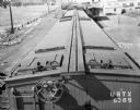
| Date: | 06 22 1943 |
|---|---|
| Description: | Elevated view of the top of an Oscar Mayer refrigerated railroad car, Chicago & Northwestern #URTX 5365 with a view of the Oscar Mayer rail yards. There is... |
| Date: | 04 15 1934 |
|---|---|
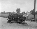
| Description: | Damaged automobiles of Leo Maly and August Steinhagen at scene of accident at Middleton Junction Road. Leo Maly was killed, his wife, Edna, and son, Paul, ... |

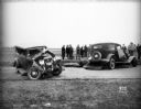
| Date: | 06 14 1930 |
|---|---|
| Description: | View from building towards five airplanes, parked in a line outdoors, at Madison Airport, Coolidge Avenue between North Street and Kedzie Street. |

| Date: | 11 02 1930 |
|---|---|
| Description: | University of Wisconsin Mechanical Engineering Building, under construction, showing scaffolding around building and Findorff Builders sign, 1513 Universit... |
| Date: | 07 24 1929 |
|---|---|
| Description: | Carbide & Carbon Chemicals Co. Pyrofax plant, 130 Fair Oaks Avenue, view looking south west. |
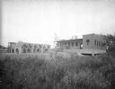
| Date: | 09 1929 |
|---|---|
| Description: | View across field towards the Carbide & Carbon Chemicals Co. Pyrofax plant under construction, 130 Fair Oaks Avenue, almost finished. |
| Date: | 09 1929 |
|---|---|
| Description: | View across field towards the Carbide & Carbon Chemicals Co. Pyrofax plant under construction, 130 Fair Oaks Avenue, almost finished. |
| Date: | 11 08 1928 |
|---|---|
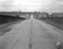
| Description: | Stretch of paved rural highway featuring a proprietary centerline joint, looking towards Mount Horeb from the east. |

| Date: | 05 25 1928 |
|---|---|
| Description: | ESBMA (East Side Business Men's Association) men clearing area for playground at Burr Jones Field at 1800 E. Washington Street. |
| Date: | 1926 |
|---|---|
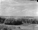
| Description: | Elevated view of Picnic Point on Lake Mendota from the University of Wisconsin-Madison Soils building. |

| Date: | 1883 |
|---|---|
| Description: | Bird's-eye map of Sauk City. |

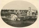
| Date: | 1871 |
|---|---|
| Description: | Like many southeastern Wisconsin villages, Edgerton was settled by Yankee immigrants in the 1830s. Though this view gives no indication of it, by 1871 toba... |

| Date: | 1858 |
|---|---|
| Description: | Elevated view from bluff looking down on city, with Lake Michigan in background. Detailed foreground with two boys playing with a grounded kite, while a ma... |
If you didn't find the material you searched for, our Library Reference Staff can help.
Call our reference desk at 608-264-6535 or email us at: