 Filter: Categories of Wisconsin Historical Images
Filter: Subject of Fields (Agriculture)
Filter: Subject of dwellings
Filter: Subject of streets
Filter: Categories of Wisconsin Historical Images
Filter: Subject of Fields (Agriculture)
Filter: Subject of dwellings
Filter: Subject of streets
| Date: | 1916 |
|---|---|
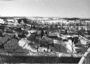
| Description: | Panoramic view of the Wingra area from the railroad tracks north of Gregory Street. Looking towards Lake Wingra, across Monroe Street. |

| Date: | 1908 |
|---|---|
| Description: | Aerial view of Camp Randall Field on the University of Wisconsin-Madison campus. University Heights is in the background. |

| Date: | 1874 |
|---|---|
| Description: | Bird's-eye map of Chippewa Falls. |

| Date: | 1881 |
|---|---|
| Description: | Bird's-eye map of Milton Junction. |
| Date: | 1907 |
|---|---|
| Description: | Caption reads: "Birdseye [sic] View of Cameron Wisconsin." Railroad cars are on railroad tracks between buildings, and houses and what may be the hi... |
| Date: | 1907 |
|---|---|
| Description: | Elevated view of Cameron. Rooftops are in the foreground, and an unpaved street is along the left. Railroad tracks cut across the street, with railroad car... |

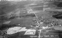
| Date: | 1909 |
|---|---|
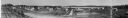
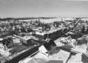
| Description: | View from the University of Wisconsin service building smokestack of south Madison, including Mills Street, Mound Street, and the Greenbush. Lake Monona is... |
| Date: | 1895 |
|---|---|
| Description: | E.S. Minorhouse on the right, Weston-Babcock house on the left. A person is standing on the sidewalk on the left in front of the Weston-Babcock House. |
| Date: | 09 1958 |
|---|---|
| Description: | University Hill Farms from an aerial perspective. |

| Date: | 1900 |
|---|---|
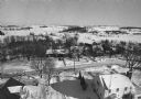
| Description: | Elevated view looking towards Monona Bay, possibly from atop the University of Wisconsin Power Plant smokestack. |

| Date: | 1955 |
|---|---|
| Description: | An aerial view of Middleton. In the foreground is a baseball field, and beyond are houses, woods, fields, and Lake Mendota. |

| Date: | 1915 |
|---|---|
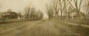
| Description: | View down road of a group of prisoners wearing striped jumpsuits doing road work while supervisors look on. A horse-drawn wagon is parked near a fence, and... |
| Date: | 1913 |
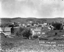
|---|---|
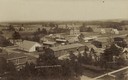
| Description: | Elevated view from hill of the town and hills in the distance. |

| Date: | 1922 |
|---|---|
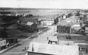
| Description: | View down an unpaved street in a residential area, and storefronts further down. Near a garage on the right is a horse-drawn wagon and automobile. Two men ... |
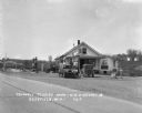
| Date: | 1931 |
|---|---|
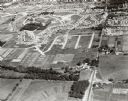
| Description: | Aerial view taken from an airplane overlooking the town of Mason. Farm fields, roads, trees, houses and other buildings are visible. |
| Date: | 1929 |
|---|---|
| Description: | Exterior view from road of gas station and "dine and dance" restaurant on Highway US-18/US-12, outside the Triangle Tourist Park. The establishment offers ... |

| Date: | 1926 |
|---|---|
| Description: | Exterior view from road of the Liberty Norwegian Lutheran Congregation. |
| Date: | 02 02 1978 |
|---|---|
| Description: | "Water tower view, looking due west." |
| Date: | 02 02 1978 |
|---|---|
| Description: | "Groundhog Day... A view from the water tower, looking northwest. The 20mm lens provides a very wide angle of view." |
| Date: | 02 02 1978 |
|---|---|
| Description: | "Water tower view, looking to the east." |
If you didn't find the material you searched for, our Library Reference Staff can help.
Call our reference desk at 608-264-6535 or email us at: