 Filter: Categories of Wisconsin Historical Images
Filter: Subject of Fields (Agriculture)
Filter: Subject of farm buildings
Filter: Subject of aerial photographs
Filter: Categories of Wisconsin Historical Images
Filter: Subject of Fields (Agriculture)
Filter: Subject of farm buildings
Filter: Subject of aerial photographs

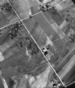
| Date: | 1958 |
|---|---|
| Description: | Aerial view of contour strip farming with the Obert Olstad farm in foreground. The Carl Backum farm is in the background. |

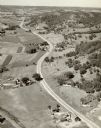
| Date: | 11 1951 |
|---|---|
| Description: | Aerial view of US Highway 14 southeast of La Crosse descending into Mormon Coulee. The original caption of the print, which is undated, describes the road ... |

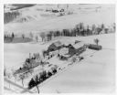
| Date: | 02 09 1949 |
|---|---|
| Description: | Three aerial views of the John Fluckiger farm and farm buildings amid snow-covered fields near Verona, operated by son Ivan Fluckiger. |

| Date: | 02 09 1949 |
|---|---|
| Description: | One of four aerial views of the Edwin Blaney farm and farm buildings surrounded by snow-covered fields. Four miles south of Madison and a mile west of U.S.... |

| Date: | 1950 |
|---|---|
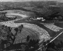
| Description: | Aerial view of a farm and surrounding fields farmed with the contour method. Shocks of grain dot several of the fields. |
| Date: | 05 1948 |
|---|---|
| Description: | "This shows where Cty Trk P & Hochheim Rd intersect. A small creek cuts through the Wm Kemp Farm." |
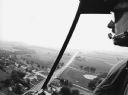
| Date: | 09 1996 |
|---|---|
| Description: | "When Pioneer Days was celebrated, visitors were given the chance to view the community from a helicopter." |
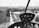
| Date: | 09 1996 |
|---|---|
| Description: | "As we approach Firemen's Park, we are at the end of our ride." |
| Date: | |
|---|---|
| Description: | Hand-tinted aerial photograph of the Apps Farm in the Wild Rose vicinity. |
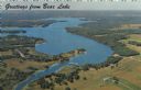
| Date: | 1967 |
|---|---|
| Description: | Aerial view of Bear Lake, with surrounding forests and farms. Caption reads: "Greetings from Bear Lake." |

| Date: | 1956 |
|---|---|
| Description: | Aerial view of residential homes, farmland and streets. |
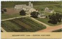
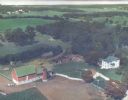
| Date: | 1952 |
|---|---|
| Description: | Aerial view of a dairy farm with white barns and a white house. Caption reads: "Mid-Lake Dairy Farm — Elkhorn, Wisconsin." |
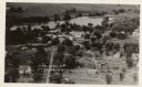
| Date: | |
|---|---|
| Description: | Aerial view of Ettrick. A river and fields are in the background. There is a church in the foreground on the left, and on the main street are commercial bu... |
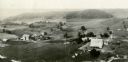
| Date: | 1930 |
|---|---|
| Description: | Aerial view of two farms, with fields and barns in a valley. This image appeared in Joseph Schafer's 1932 book The Wisconsin Lead Region, on a photo... |
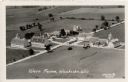
| Date: | 1931 |
|---|---|
| Description: | Aerial view of a farm complex, including a farmhouse and several large buildings. Caption reads: "Wern Farms, Waukesha, Wis." |
| Date: | 1955 |
|---|---|
| Description: | Aerial view of a farm in winter, with the farmhouse, barn, and outbuildings blanketed in snow. The name Cedar Spring Farm is on the barn. Another farm is i... |
| Date: | |
|---|---|
| Description: | Aerial view of a road, with several farms, fields and hills along it. Caption reads: "U.S. 16 near La Crosse, Wis." |
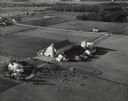
| Date: | 10 05 1948 |
|---|---|
| Description: | Aerial photograph of the Baumgartner Dairy Farm, one half mile east of Three Lakes, WI. |

| Date: | 1948 |
|---|---|
| Description: | Aerial view of a farm in mid-winter. Snow blankets the ground and some of the buildings. An orchard is in the foreground. |
| Date: | 1948 |
|---|---|
| Description: | Aerial view of terraced farm land with shocks of harvested corn. A farm is in the valley and trees cover much of the hills. |
If you didn't find the material you searched for, our Library Reference Staff can help.
Call our reference desk at 608-264-6535 or email us at: