Filter: Categories of Wisconsin Historical Images
Filter: Subject of Fields (Agriculture)
Filter: Subject of human settlements
Filter: Subject of church buildings
Filter: Categories of Wisconsin Historical Images
Filter: Subject of Fields (Agriculture)
Filter: Subject of human settlements
Filter: Subject of church buildings

| Date: | 1950 |
|---|---|
| Description: | Aerial view of the Frank Lloyd-Wright-dsigned Unitarian Church under construction and the Veteran's Administration Hospital, also under construction, to th... |

| Date: | 1874 |
|---|---|
| Description: | Bird's-eye map of Chippewa Falls. |

| Date: | 1878 |
|---|---|
| Description: | Bird's-eye map of Kewaskum. Includes a list of hotels, churches, post office, railroad depot, etc. |

| Date: | 1881 |
|---|---|
| Description: | Bird's-eye map of Milton Junction. |

| Date: | 1858 |
|---|---|
| Description: | Elevated view from bluff looking down on city, with Lake Michigan in background. Detailed foreground with two boys playing with a grounded kite, while a ma... |

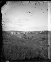
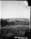
| Date: | 1874 |
|---|---|
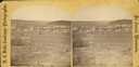
| Description: | Distant view of the town from a hill with houses, garden plots, businesses and churches. |
| Date: | 1874 |
|---|---|
| Description: | View of New Glarus from a neighboring hill. A man, wearing a hat and suit, and five children, girls and boys, are posing along the fence in the foreground.... |
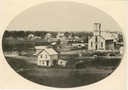
| Date: | 1874 |
|---|---|
| Description: | View, from a distance, of New Glarus. A hill, trees and fences are in the foreground. |
| Date: | 1876 |
|---|---|
| Description: | A view of the town of Lodi as viewed from the hill north of the cemetery. |
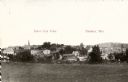
| Date: | 1900 |
|---|---|
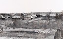
| Description: | View from hill across field towards farmhouses, dwellings and churches along a road. In the foreground are stumps. Caption reads: "Big Falls, Wis." |
| Date: | 1928 |
|---|---|
| Description: | View from hill of uptown Cross Plains with the Catholic Church (St. Francis Xavier) and farmhouses. |
| Date: | 1911 |
|---|---|
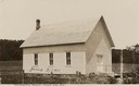
| Description: | View of the church, with a field and trees in the background. Caption reads: "Swedish Free Mission Church, Ella, Wis." Handwritten on church: "June 3/1911"... |
| Date: | 1920 |
|---|---|
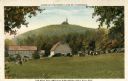
| Description: | View of Holy Hill, with a field and the Hillside Hotel in the foreground. Captions read: "America's Favorite Place of Pilgrimage" and "The Holy Hill and Hi... |

| Date: | 1955 |
|---|---|
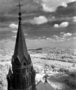
| Description: | Elevated view from Holy Hill of the valley below. The roof and side of the church is on the left. |
| Date: | 1963 |
|---|---|
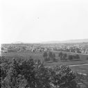
| Description: | Elevated view of the Kettle Moraine area from Holy Hill. |

| Date: | 10 1928 |
|---|---|
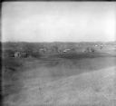
| Description: | Aerial view of Sun Prairie, including the central business district, residences, and the surrounding countryside stretching to the horizon. |
| Date: | 1912 |
|---|---|
| Description: | Elevated view of Wausau from the edge of town looking toward residences and businesses. Hills are in the far background. |

| Date: | 1910 |
|---|---|
| Description: | Elevated view of the First Presbyterian church and two mansions. The Mahoning river and a park is in the foreground, and other parts of the town stretch in... |
If you didn't find the material you searched for, our Library Reference Staff can help.
Call our reference desk at 608-264-6535 or email us at: