Filter: Categories of Wisconsin Historical Images
Filter: Subject of Fields (Agriculture)
Filter: Subject of human settlements
Filter: Subject of roads
Filter: Categories of Wisconsin Historical Images
Filter: Subject of Fields (Agriculture)
Filter: Subject of human settlements
Filter: Subject of roads

| Date: | 1873 |
|---|---|
| Description: | Main Street, with its dirt, ruts, cows (and presumably manure), but wide enough for easy hitching of wagons and teams. |

| Date: | 01 1934 |
|---|---|
| Description: | Aerial view of New Butler, in Waukesha County. |

| Date: | 1910 |
|---|---|
| Description: | View of La Pointe taken from Big Bay Road on Madeline Island. |

| Date: | 1878 |
|---|---|
| Description: | Bird's-eye map of Kewaskum. Includes a list of hotels, churches, post office, railroad depot, etc. |
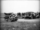
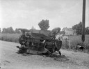
| Date: | 04 15 1934 |
|---|---|
| Description: | Damaged automobiles of Leo Maly and August Steinhagen at scene of accident at Middleton Junction Road. Leo Maly was killed, his wife, Edna, and son, Paul, ... |
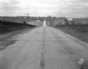
| Date: | 11 08 1928 |
|---|---|
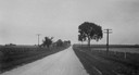
| Description: | Stretch of paved rural highway featuring a proprietary centerline joint, looking towards Mount Horeb from the east. |

| Date: | 1871 |
|---|---|
| Description: | Like many southeastern Wisconsin villages, Edgerton was settled by Yankee immigrants in the 1830s. Though this view gives no indication of it, by 1871 toba... |

| Date: | 1884 |
|---|---|
| Description: | Bird's-eye view drawing of the grounds of Villa Louis, the estate of the fur trading Dousman family. After the death of H. Louis Dousman's mother in 1882, ... |
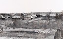
| Date: | 1900 |
|---|---|
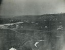
| Description: | View from hill across field towards farmhouses, dwellings and churches along a road. In the foreground are stumps. Caption reads: "Big Falls, Wis." |

| Date: | 1905 |
|---|---|
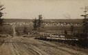
| Description: | Aerial view of town, with several large buildings along railroad tracks in the foreground, and fields and trees in the distance. Pedestrians are walking al... |
| Date: | 07 15 1925 |
|---|---|
| Description: | Natesta cabin site in Clinton. View down road, with a fence on the right, and fields on both sides. |
| Date: | 1908 |
|---|---|
| Description: | Caption reads: "Crandon—Wis. From Teachworth Hill". |

| Date: | 05 10 1928 |
|---|---|
| Description: | The Lutheran Church and buildings, seen from Lutheran Church Hill. |
| Date: | 1860 |
|---|---|
| Description: | Elevated view of multiple buildings in Cross Plains from Lutheran Church Hill. Many roads and fences cross the fields. Wooded hills are in the background. ... |

| Date: | 1965 |
|---|---|
| Description: | Aerial view of town and Highway 66. |

| Date: | 06 16 1949 |
|---|---|
| Description: | Freda Winterble property, 901 University Bay Drive, looking north toward Lake Mendota, showing trees on right side of road and house on the left, 928 Unive... |

| Date: | 1910 |
|---|---|
| Description: | View across field toward the hospital. Caption reads: "St. Vincent Hospital, Green Bay, Wis." |
| Date: | 1908 |
|---|---|
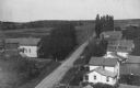
| Description: | Elevated view of homes alongside a road in Hika (also known as Centerville). Handwritten on two of the buildings on the right are: "Ma's house." and "Louis... |
If you didn't find the material you searched for, our Library Reference Staff can help.
Call our reference desk at 608-264-6535 or email us at: