Filter: Categories of Wisconsin Historical Images
Filter: Subject of Fields (Agriculture)
Filter: Subject of human settlements
Filter: Year of 1800-1899
Filter: Categories of Wisconsin Historical Images
Filter: Subject of Fields (Agriculture)
Filter: Subject of human settlements
Filter: Year of 1800-1899

| Date: | 1873 |
|---|---|
| Description: | Main Street, with its dirt, ruts, cows (and presumably manure), but wide enough for easy hitching of wagons and teams. |

| Date: | 1862 |
|---|---|
| Description: | Camp Randall looking southwest. In April 1861, Governor Alexander Randall asked that the State Agricultural Society fairgrounds be converted into a militar... |

| Date: | 1860 |
|---|---|
| Description: | A general view of the Lane residence, which is the birthplace of Carrie Lane, later Carrie Chapman Catt, noted woman suffrage leader. |
| Date: | 1886 |
|---|---|
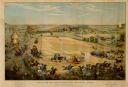
| Description: | Color lithographed color advertising poster showing a McCormick grain binder at the Civil War battle of Gettysburg. The poster was based on a cyclorama by ... |
| Date: | 1875 |
|---|---|
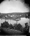
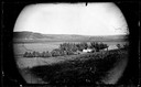
| Description: | A view of the village from a nearby bluff across a pond. Men, women and children, standing spaced apart, are posing in the field near the pond. |
| Date: | 1899 |
|---|---|
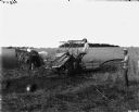
| Description: | Three farmers harvest grain with McCormick horse-drawn grain binder. One farmer is sitting aboard the binder guiding horses while two men, one with scythe ... |

| Date: | 1886 |
|---|---|
| Description: | Cover of an advertising brochure for the Milwaukee Harvester Company featuring a color chromolithograph illustration of a farmer in a field operating a hor... |

| Date: | 1874 |
|---|---|
| Description: | Bird's-eye map of Chippewa Falls. |

| Date: | 1878 |
|---|---|
| Description: | Bird's-eye map of Kewaskum. Includes a list of hotels, churches, post office, railroad depot, etc. |

| Date: | 1881 |
|---|---|
| Description: | Bird's-eye map of Milton Junction. |

| Date: | 1883 |
|---|---|
| Description: | Bird's-eye map of Sauk City. |

| Date: | 1871 |
|---|---|
| Description: | Like many southeastern Wisconsin villages, Edgerton was settled by Yankee immigrants in the 1830s. Though this view gives no indication of it, by 1871 toba... |

| Date: | 1858 |
|---|---|
| Description: | Elevated view from bluff looking down on city, with Lake Michigan in background. Detailed foreground with two boys playing with a grounded kite, while a ma... |

| Date: | 1884 |
|---|---|
| Description: | Bird's-eye view drawing of the grounds of Villa Louis, the estate of the fur trading Dousman family. After the death of H. Louis Dousman's mother in 1882, ... |
| Date: | 1873 |
|---|---|
| Description: | View across field towards the Amund Rustebakke farm. Twelve haystacks dominate the left and center of the image, and two people are standing on top of the ... |
| Date: | 1880 |
|---|---|
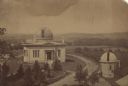
| Description: | Elevated view of the University of Wisconsin-Madison Washburn Observatory. Hill, trees and fields are in the background. A man is standing near a small obs... |

| Date: | 09 10 1875 |
|---|---|
| Description: | View looking west across the area once occupied by Camp Randall during the Civil War and towards the Breese Stevens farm property. The Madison Centennial ... |

| Date: | 1874 |
|---|---|
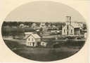
| Description: | Distant view of the town from a hill with houses, garden plots, businesses and churches. |
If you didn't find the material you searched for, our Library Reference Staff can help.
Call our reference desk at 608-264-6535 or email us at: