Filter: Categories of Wisconsin Historical Images
Filter: Subject of Fields (Agriculture)
Filter: Subject of industrial buildings
Filter: Subject of botany
Filter: Categories of Wisconsin Historical Images
Filter: Subject of Fields (Agriculture)
Filter: Subject of industrial buildings
Filter: Subject of botany
| Date: | 1872 |
|---|---|
| Description: | Galena (lead sulfide) was melted at this open hearth furnace owned by Richard Straw and Company on the Roundtree Branch of the Little Platte River. The men... |
| Date: | 1923 |
|---|---|
| Description: | The hangar and three airplanes (a Canuck and a J-1 Standard) at the airport operated by the Larson Brothers of Larsen, Wisconsin. The field was both the mo... |

| Date: | 1874 |
|---|---|
| Description: | Bird's-eye map of Chippewa Falls. |
| Date: | 05 26 1932 |
|---|---|
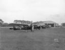
| Description: | At Royal Airport, a line of airplanes are parked in a row in a field. In the background is a hangar with automobiles parked nearby. |

| Date: | 06 14 1930 |
|---|---|
| Description: | View from building towards five airplanes, parked in a line outdoors, at Madison Airport, Coolidge Avenue between North Street and Kedzie Street. |
| Date: | 09 1929 |
|---|---|
| Description: | View across field towards the Carbide & Carbon Chemicals Co. Pyrofax plant under construction, 130 Fair Oaks Avenue, almost finished. |
| Date: | 09 1929 |
|---|---|
| Description: | View across field towards the Carbide & Carbon Chemicals Co. Pyrofax plant under construction, 130 Fair Oaks Avenue, almost finished. |
| Date: | 1907 |
|---|---|
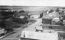
| Description: | Elevated view of Cameron. Rooftops are in the foreground, and an unpaved street is along the left. Railroad tracks cut across the street, with railroad car... |
| Date: | 1920 |
|---|---|
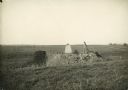
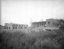
| Description: | Charcoal kiln in an overgrown field. Producing charcoal was once a fairly large industry in De Pere. |
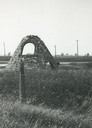
| Date: | 1920 |
|---|---|
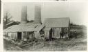
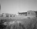
| Description: | Charcoal kiln in ruins in a field beyond a fence, with electric power lines in the background. |

| Date: | 10 1928 |
|---|---|
| Description: | Aerial view of Sun Prairie, including the central business district, residences, and the surrounding countryside stretching to the horizon. |
| Date: | 1948 |
|---|---|
| Description: | Aerial view of the Kimberly-Clark Paper Mill on the Fox River, just east of Appleton. |
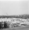
| Date: | 1912 |
|---|---|
| Description: | Winter view over fields of town with hills in the far background. |
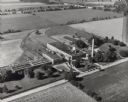
| Date: | 07 1949 |
|---|---|
| Description: | Aerial view of the Carnation Company milk condensery. |
| Date: | 1880 |
|---|---|
| Description: | Illustration of an elevated view over rooftops looking towards Oshkosh. There are chimneys along the horizon with smoke rising into the sky. A river is alo... |

| Date: | |
|---|---|
| Description: | Elevated view of the oil rigs. Oil was first discovered at Glen Pool oil on November 22, 1905 by Robert Galbreath and Frank Chesley. The Glenn Pool has pro... |

| Date: | 1920 |
|---|---|
| Description: | Elevated view of Tulsa, and its vast oil fields. Caption reads: "Oil Fields Near Tulsa, Okla." |
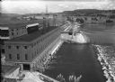
| Date: | 1936 |
|---|---|
| Description: | Elevated view of the power dam on the Wisconsin River at Prairie du Sac. |

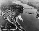
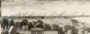
| Date: | 1887 |
|---|---|
| Description: | Elevated view of Marinette looking toward the mouth of the river from the tower of City Hall. Fences, fields, and industrial buildings are in the foregroun... |
If you didn't find the material you searched for, our Library Reference Staff can help.
Call our reference desk at 608-264-6535 or email us at: