Filter: Categories of Wisconsin Historical Images
Filter: Subject of Fields (Agriculture)
Filter: Subject of intellectual life
Filter: Creator Name of Unknown
Filter: Categories of Wisconsin Historical Images
Filter: Subject of Fields (Agriculture)
Filter: Subject of intellectual life
Filter: Creator Name of Unknown

| Date: | 1908 |
|---|---|
| Description: | Aerial view of Camp Randall Field on the University of Wisconsin-Madison campus. University Heights is in the background. |
| Date: | 1882 |
|---|---|
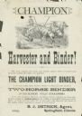
| Description: | Advertising handbill for the Champion harvester and binder. Includes the text: "the Champion light binder, is the only simple, light, durable, efficient wo... |
| Date: | 08 1928 |
|---|---|
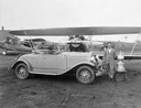
| Description: | John P. Wood of Wausau, winner of the 1928 National Air Reliability Tour, with his "Waco from Wausau." Also in the photograph are Wood's prizes: the Edsel ... |
| Date: | 1988 |
|---|---|
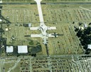
| Description: | Aerial view of the 1988 EAA (Experimental Aviation Association) Convention and Fly-in at Wittman Field. On the ground is the Concorde and a B-1 Bomber. |

| Date: | 1874 |
|---|---|
| Description: | Bird's-eye map of Chippewa Falls. |

| Date: | 1881 |
|---|---|
| Description: | Bird's-eye map of Milton Junction. |

| Date: | 1965 |
|---|---|
| Description: | Aerial view of downtown Big Falls and the Little Wolf River. The Little Wolf River is at lower right. |

| Date: | 1905 |
|---|---|
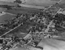
| Description: | Aerial view of town, with several large buildings along railroad tracks in the foreground, and fields and trees in the distance. Pedestrians are walking al... |

| Date: | 1965 |
|---|---|
| Description: | Aerial view of town and Highway 66. |

| Date: | 1930 |
|---|---|
| Description: | Aerial view above Shorewood Hills near Madison, looking northeast. |

| Date: | 1905 |
|---|---|
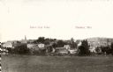
| Description: | View across fields toward the town. Caption reads: "Birdseye[sic] view of Mauston, Wis." |
| Date: | 1965 |
|---|---|
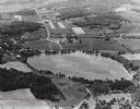
| Description: | Aerial view looking west-northwest over Silver Lake. |
| Date: | 1965 |
|---|---|
| Description: | Aerial view, looking west, with potato warehouses in the foreground and a pallet factory and junkyard behind them at right. |

| Date: | 1960 |
|---|---|
| Description: | Aerial view of the construction of the interstate highway near Mirror Lake, showing only the early stages of the bridge construction. |
| Date: | 1967 |
|---|---|
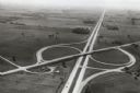
| Description: | Intersection of US Highway 41 and Wisconsin Highway 26 near Oshkosh. |

| Date: | 1979 |
|---|---|
| Description: | Aerial view of Interstate I-90/94 at Camp Douglas, looking northwest. |
| Date: | 1895 |
|---|---|
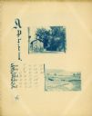
| Description: | Page showing the month of April from the Hillside Home School calendar. Included are two small cyanotype photographs, one of a house and the other of a fie... |
If you didn't find the material you searched for, our Library Reference Staff can help.
Call our reference desk at 608-264-6535 or email us at: