Filter: Categories of Wisconsin Historical Images
Filter: Subject of Fields (Agriculture)
Filter: Subject of intellectual life
Filter: Subject of dwellings
Filter: Categories of Wisconsin Historical Images
Filter: Subject of Fields (Agriculture)
Filter: Subject of intellectual life
Filter: Subject of dwellings

| Date: | 1908 |
|---|---|
| Description: | Aerial view of Camp Randall Field on the University of Wisconsin-Madison campus. University Heights is in the background. |

| Date: | 01 1934 |
|---|---|
| Description: | Aerial view of New Butler, in Waukesha County. |

| Date: | 1874 |
|---|---|
| Description: | Bird's-eye map of Chippewa Falls. |

| Date: | 1881 |
|---|---|
| Description: | Bird's-eye map of Milton Junction. |

| Date: | 1884 |
|---|---|
| Description: | Bird's-eye view drawing of the grounds of Villa Louis, the estate of the fur trading Dousman family. After the death of H. Louis Dousman's mother in 1882, ... |

| Date: | 1632 |
|---|---|
| Description: | The Wisconsin portion of Champlain's 1632 map, augmented since the previous one, for navigation according to the true Meridien, by Sieur de Champlain. The ... |

| Date: | 1905 |
|---|---|
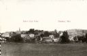
| Description: | Aerial view of town, with several large buildings along railroad tracks in the foreground, and fields and trees in the distance. Pedestrians are walking al... |
| Date: | 1907 |
|---|---|
| Description: | Caption reads: "Birdseye [sic] View of Cameron Wisconsin." Railroad cars are on railroad tracks between buildings, and houses and what may be the hi... |

| Date: | 10 1928 |
|---|---|
| Description: | Aerial view of Sun Prairie, including the central business district, residences, and the surrounding countryside stretching to the horizon. |

| Date: | 11 1951 |
|---|---|
| Description: | Aerial view of US Highway 14 southeast of La Crosse descending into Mormon Coulee. The original caption of the print, which is undated, describes the road ... |
| Date: | 1895 |
|---|---|
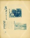
| Description: | Page showing the month of April from the Hillside Home School calendar. Included are two small cyanotype photographs, one of a house and the other of a fie... |
| Date: | 09 1958 |
|---|---|
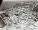
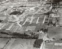
| Description: | Aerial view of University Farms neighborhood near Lake Mendota. |
| Date: | 09 1958 |
|---|---|
| Description: | University Hill Farms from an aerial perspective. |

| Date: | 1910 |
|---|---|
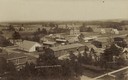
| Description: | Aerial view looking toward Lake Wingra. In the foreground is the Yawkey-Crowley Lumber Yard. The company built it's warehouse at 1542 Monroe Street between... |
| Date: | 01 30 1949 |
|---|---|
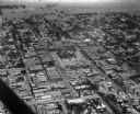
| Description: | Aerial view of town, with a large building on a town square in the center. The edges of town are bordered by fields and farms. |

| Date: | 02 09 1949 |
|---|---|
| Description: | Three aerial views of the John Fluckiger farm and farm buildings amid snow-covered fields near Verona, operated by son Ivan Fluckiger. |

| Date: | 02 09 1949 |
|---|---|
| Description: | One of four aerial views of the Edwin Blaney farm and farm buildings surrounded by snow-covered fields. Four miles south of Madison and a mile west of U.S.... |

| Date: | 04 30 1949 |
|---|---|
| Description: | Aerial photograph of Blanchardville. |

| Date: | 1955 |
|---|---|
| Description: | An aerial view of Middleton. In the foreground is a baseball field, and beyond are houses, woods, fields, and Lake Mendota. |
If you didn't find the material you searched for, our Library Reference Staff can help.
Call our reference desk at 608-264-6535 or email us at: