Filter: Categories of Wisconsin Historical Images
Filter: Subject of Fields (Agriculture)
Filter: Subject of intellectual life
Filter: Subject of hills
Filter: Categories of Wisconsin Historical Images
Filter: Subject of Fields (Agriculture)
Filter: Subject of intellectual life
Filter: Subject of hills

| Date: | 1958 |
|---|---|
| Description: | Aerial view of contour strip farming with the Obert Olstad farm in foreground. The Carl Backum farm is in the background. |
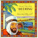
| Date: | 1929 |
|---|---|
| Description: | Advertising folder for Deering 10-20 and 15-30 tractors, showing an Arab man in the foreground and tractors at work in the background. Printed for Algiers,... |

| Date: | 1878 |
|---|---|
| Description: | Bird's-eye map of Kewaskum. Includes a list of hotels, churches, post office, railroad depot, etc. |

| Date: | 1957 |
|---|---|
| Description: | Aerial view of Yellowstone Lake and surrounding countryside. |

| Date: | 1905 |
|---|---|
| Description: | View across fields toward the town. Caption reads: "Birdseye[sic] view of Mauston, Wis." |

| Date: | 11 1951 |
|---|---|
| Description: | Aerial view of US Highway 14 southeast of La Crosse descending into Mormon Coulee. The original caption of the print, which is undated, describes the road ... |
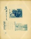
| Date: | 1895 |
|---|---|
| Description: | Page showing the month of April from the Hillside Home School calendar. Included are two small cyanotype photographs, one of a house and the other of a fie... |

| Date: | |
|---|---|
| Description: | Mountain meadow at Interstate Park. This area was an ancient lake which became filled with peat. Prehistoric bison bones, copper points, and flint arrow po... |
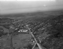
| Date: | 03 28 1949 |
|---|---|
| Description: | Aerial photographs of Richland Center, Wisconsin. |
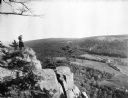
| Date: | |
|---|---|
| Description: | View of a woman taking a photograph from Lookout Cliff at Devil's Lake. Below, a train runs through a field surrounded by trees. |

| Date: | 1950 |
|---|---|
| Description: | Aerial view of a farm and surrounding fields farmed with the contour method. Shocks of grain dot several of the fields. |
| Date: | 07 29 1909 |
|---|---|
| Description: | Aerial view of the downtown area, including a bridge spanning the Trempealeau River. Caption reads: "View of Arcadia, Wisconsin." |
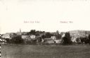
| Date: | 05 22 1906 |
|---|---|
| Description: | Aerial view of the city and rolling hills in the background. A bridge crossing the Trempealeau River is also visible. |
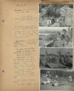
| Date: | 07 22 1941 |
|---|---|
| Description: | Scrapbook page of trip highlights from a bike hosteling trip to Pine Bluff (Dane County), Sauk City (Sauk County), and Okee (Columbia County), sponsored by... |

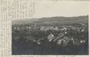
| Date: | 1921 |
|---|---|
| Description: | Elevated view of Woodstock, with dwellings, farm buildings and a church. Pastures and fields surround the town. |

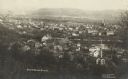
| Date: | 1908 |
|---|---|
| Description: | Elevated photographic postcard view of town showing homes and businesses. A windmill is in the foreground. The school is on the far edge of town on the lef... |
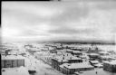
| Date: | 1918 |
|---|---|
| Description: | Elevated view of Archangel [Archangelsk], Russia. There are pedestrians on the snowy street below, including horses and sleighs. Buildings and dwellings li... |
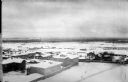
| Date: | 1918 |
|---|---|
| Description: | Elevated view of Archangel [Archangelsk], Russia, with buildings, dwellings and yards. Pedestrians are walking on the street below. In the distance are fie... |
If you didn't find the material you searched for, our Library Reference Staff can help.
Call our reference desk at 608-264-6535 or email us at: