 Filter: Categories of Wisconsin Historical Images
Filter: Subject of Fields (Agriculture)
Filter: Subject of intellectual life
Filter: Subject of landscape
Filter: Categories of Wisconsin Historical Images
Filter: Subject of Fields (Agriculture)
Filter: Subject of intellectual life
Filter: Subject of landscape

| Date: | 1958 |
|---|---|
| Description: | Aerial view of contour strip farming with the Obert Olstad farm in foreground. The Carl Backum farm is in the background. |
| Date: | 06 1962 |
|---|---|
| Description: | Distant view of U.S helicopters over the Delta Region of South Vietnam taken by Dickey Chapelle, a freelance photographer from Milwaukee. |
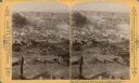
| Date: | 1889 |
|---|---|
| Description: | Stereograph from the Chicago Panorama of the Battle of Gettysburg Representing Pickett's Charge at 4 P.M., July 3rd, 1863: Death of Confederate General Arm... |
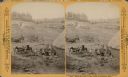
| Date: | 1889 |
|---|---|
| Description: | Stereograph from the Chicago Panorama of the Battle of Gettysburg Representing Pickett's Charge at 4 P.M., July 3rd, 1863: Field Hospital on the Right of C... |

| Date: | |
|---|---|
| Description: | Aerial view of a train crossing the East River in a rural community south of Green Bay. Some buildings are visible to the right and the background of the i... |

| Date: | 1957 |
|---|---|
| Description: | Aerial view of Yellowstone Lake and surrounding countryside. |

| Date: | 11 1951 |
|---|---|
| Description: | Aerial view of US Highway 14 southeast of La Crosse descending into Mormon Coulee. The original caption of the print, which is undated, describes the road ... |

| Date: | 1979 |
|---|---|
| Description: | Aerial view of Interstate I-90/94 at Camp Douglas, looking northwest. |

| Date: | |
|---|---|
| Description: | Mountain meadow at Interstate Park. This area was an ancient lake which became filled with peat. Prehistoric bison bones, copper points, and flint arrow po... |

| Date: | 04 30 1949 |
|---|---|
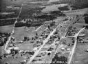
| Description: | Aerial photograph of Blanchardville. |

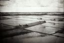
| Date: | 04 30 1949 |
|---|---|
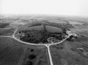
| Description: | Aerial photograph of contour farming in Wisconsin. |
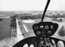
| Date: | |
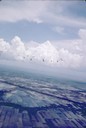
|---|---|
| Description: | Elevated view of helicopters flying over rice fields in Vietnam. |

| Date: | 1950 |
|---|---|
| Description: | Aerial view of a farm and surrounding fields farmed with the contour method. Shocks of grain dot several of the fields. |
| Date: | 1936 |
|---|---|
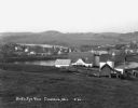
| Description: | Aerial view of Cable, in northern Wisconsin. Text at foot reads: "Airplane View of Cable, Wis. 244." |
| Date: | 1930 |
|---|---|
| Description: | View from hill of a farm near a pond. There are homes along the far shoreline, and a lake and hills in the far background. |
| Date: | 07 22 1941 |
|---|---|
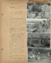
| Description: | Scrapbook page of trip highlights from a bike hosteling trip to Pine Bluff (Dane County), Sauk City (Sauk County), and Okee (Columbia County), sponsored by... |
| Date: | 09 1996 |
|---|---|
| Description: | "As you look north, North Pole Road intersects DD. At the right is Theresa Station." |
| Date: | 09 1996 |
|---|---|
| Description: | "As we approach Firemen's Park, we are at the end of our ride." |
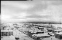
| Date: | 1918 |
|---|---|
| Description: | Elevated view of Archangel [Archangelsk], Russia. There are pedestrians on the snowy street below, including horses and sleighs. Buildings and dwellings li... |
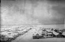
| Date: | 1918 |
|---|---|
| Description: | Elevated view of Archangel [Archangelsk], Russia. There are pedestrians on the snowy street below. Buildings and dwellings line the streets. In the backgro... |
If you didn't find the material you searched for, our Library Reference Staff can help.
Call our reference desk at 608-264-6535 or email us at: