 Filter: Categories of Wisconsin Historical Images
Filter: Subject of Fields (Agriculture)
Filter: Subject of intellectual life
Filter: Subject of rivers
Filter: Categories of Wisconsin Historical Images
Filter: Subject of Fields (Agriculture)
Filter: Subject of intellectual life
Filter: Subject of rivers

| Date: | 1874 |
|---|---|
| Description: | Bird's-eye map of Chippewa Falls. |

| Date: | 1878 |
|---|---|
| Description: | Bird's-eye map of Kewaskum. Includes a list of hotels, churches, post office, railroad depot, etc. |

| Date: | 1632 |
|---|---|
| Description: | The Wisconsin portion of Champlain's 1632 map, augmented since the previous one, for navigation according to the true Meridien, by Sieur de Champlain. The ... |

| Date: | 1965 |
|---|---|
| Description: | Aerial view of downtown Big Falls and the Little Wolf River. The Little Wolf River is at lower right. |

| Date: | |
|---|---|
| Description: | Aerial view of a train crossing the East River in a rural community south of Green Bay. Some buildings are visible to the right and the background of the i... |
| Date: | 1948 |
|---|---|
| Description: | Aerial view of the Kimberly-Clark Paper Mill on the Fox River, just east of Appleton. |

| Date: | 1960 |
|---|---|
| Description: | Aerial view of the construction of the interstate highway near Mirror Lake, showing only the early stages of the bridge construction. |
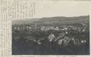
| Date: | 07 29 1909 |
|---|---|
| Description: | Aerial view of the downtown area, including a bridge spanning the Trempealeau River. Caption reads: "View of Arcadia, Wisconsin." |
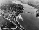
| Date: | 05 22 1906 |
|---|---|
| Description: | Aerial view of the city and rolling hills in the background. A bridge crossing the Trempealeau River is also visible. |
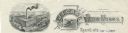
| Date: | |
|---|---|
| Description: | Memohead of the J.I. Case Plow Works of Racine, Wisconsin, with an elevated view of the company plant and a smaller scene set on a scroll of a man driving ... |
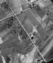
| Date: | 05 1948 |
|---|---|
| Description: | "This shows where Cty Trk P & Hochheim Rd intersect. A small creek cuts through the Wm Kemp Farm." |
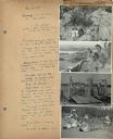
| Date: | 07 22 1941 |
|---|---|
| Description: | Scrapbook page of trip highlights from a bike hosteling trip to Pine Bluff (Dane County), Sauk City (Sauk County), and Okee (Columbia County), sponsored by... |

| Date: | 09 1996 |
|---|---|
| Description: | "Theresa's Bonduel & Wisconsin Streets from the air." |
| Date: | 09 1996 |
|---|---|
| Description: | "This is Theresa Station. Note the Rock River and Soo Line Railroad track." |
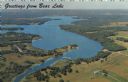
| Date: | 1967 |
|---|---|
| Description: | Aerial view of Bear Lake, with surrounding forests and farms. Caption reads: "Greetings from Bear Lake." |
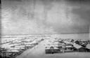
| Date: | 1918 |
|---|---|
| Description: | Elevated view of Archangel [Archangelsk], Russia. There are pedestrians on the snowy street below. Buildings and dwellings line the streets. In the backgro... |

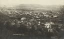
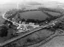
| Date: | 1910 |
|---|---|
| Description: | Aerial view along river toward Darlington. Caption reads: "Bird's-Eye View, Darlington, Wis." |
If you didn't find the material you searched for, our Library Reference Staff can help.
Call our reference desk at 608-264-6535 or email us at:


