 Filter: Categories of Wisconsin Historical Images
Filter: Subject of Fields (Agriculture)
Filter: Subject of lakes
Filter: Categories of Wisconsin Historical Images
Filter: Subject of Fields (Agriculture)
Filter: Subject of lakes

| Date: | 1908 |
|---|---|
| Description: | Panoramic view of Madison taken from Summit Avenue looking East South East toward Lake Monona. Included in the view are the Camp Randall bleachers, St. Rap... |

| Date: | 1925 |
|---|---|
| Description: | View from bluff of Crystal Lake and surrounding rolling hills. There is a dairy farm in the foreground at the bottom of the bluff. Cows are grazing in fiel... |

| Date: | |
|---|---|
| Description: | Elevated view of Lake Marion, and the railroad tracks that run along it on the left. A train belching smoke is coming up the tracks. A road runs along the ... |
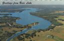
| Date: | 1967 |
|---|---|
| Description: | Aerial view of Bear Lake, with surrounding forests and farms. Caption reads: "Greetings from Bear Lake." |
| Date: | |
|---|---|
| Description: | Slightly elevated view over fields of the University of Wisconsin-Madison, showing Bascom Hall, the Observatory, and King Hall from University Heights. Lak... |

| Date: | |
|---|---|
| Description: | An aerial view of Governor's Island. A cutout of an arrow has been added. |

| Date: | 1895 |
|---|---|
| Description: | Elevated view from bluffs, looking north-east toward Lake City, Minnesota and Lake Pepin of the Mississippi River. |

| Date: | |
|---|---|
| Description: | Elevated view of the town of Hillsboro and Field Veterans Memorial Lake. There are buildings, houses, hills, and trees. The Hillsboro Mill is on the right ... |

| Date: | 1950 |
|---|---|
| Description: | Aerial view of town, showing all of Lake Metonga in the background. Caption reads: "Greetings from Crandon, Wisconsin." |

| Date: | 1950 |
|---|---|
| Description: | Aerial view of the Island City surrounded by the waters of Beaver Dam Lake, and by a vacation and recreation area that includes some fifty lakes within a r... |

| Date: | 1900 |
|---|---|
| Description: | Elevated view of Madison through trees. Lake Mendota, buildings of the University of Wisconsin-Madison, including the Washburn Observatory are along the sh... |

| Date: | 1950 |
|---|---|
| Description: | Color photograph of an aerial view of Lake Wissota looking east on Highway 29. Many resorts are in the area. Lake Wissota is one of the largest man-made la... |

| Date: | 1900 |
|---|---|
| Description: | Elevated view of a man using a binder in a field. Sheaves of wheat are distributed in the field, and two other men are standing near the binder. There is a... |

| Date: | 1900 |
|---|---|
| Description: | View across field towards man using horse-drawn binder in a field. Two other people are standing in the field, and two horses are standing on the far left.... |

| Date: | 1900 |
|---|---|
| Description: | View across field towards a man using a horse-drawn reaper in a field. Behind him on the left is a man using a rake to bind the grain. In the background is... |

| Date: | 1900 |
|---|---|
| Description: | Right side view of a man using a horse-drawn reaper in a field. Behind him on the left is a man. In the background is a lake. |

| Date: | 1937 |
|---|---|
| Description: | Pictorial map showing historical events and locations within the state of Wisconsin, as well as waterways and counties. Original caption on the bottom marg... |

| Date: | 1831 |
|---|---|
| Description: | This map shows the land that makes up Michigan, Wisconsin, Minnesota, Indiana, and parts of Canada. The Great Lakes are displayed prominently, along with s... |

| Date: | |
|---|---|
| Description: | Fox Bluff farm on the shore of Lake Mendota, owned by Stanley Hanks. On the left is a windmill, and a number of outbuildings are near the barn. |

| Date: | |
|---|---|
| Description: | The Stanley Hanks cottage at Fox Bluff on the shore of Lake Mendota. There is a fence around the property, and a boat is pulled up on the shoreline. |
If you didn't find the material you searched for, our Library Reference Staff can help.
Call our reference desk at 608-264-6535 or email us at: