 Filter: Categories of Wisconsin Historical Images
Filter: Subject of Fields (Agriculture)
Filter: Subject of land
Filter: Subject of commercial buildings
Filter: Categories of Wisconsin Historical Images
Filter: Subject of Fields (Agriculture)
Filter: Subject of land
Filter: Subject of commercial buildings

| Date: | 1874 |
|---|---|
| Description: | Bird's-eye map of Chippewa Falls. |
| Date: | 1907 |
|---|---|
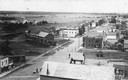
| Description: | Elevated view of Cameron. Rooftops are in the foreground, and an unpaved street is along the left. Railroad tracks cut across the street, with railroad car... |

| Date: | 1900 |
|---|---|
| Description: | Elevated view of the brewery dwarfed by the overhead bluffs. The brewery was built by William Schmitz. George Scheibl ran the brewery from 1899 until his d... |

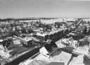
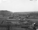
| Date: | 1910 |
|---|---|
| Description: | Elevated view across field towards homes and buildings. |

| Date: | 04 30 1949 |
|---|---|
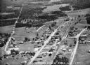
| Description: | Aerial photograph of Blanchardville. |
| Date: | 1936 |
|---|---|
| Description: | Aerial view of Cable, in northern Wisconsin. Text at foot reads: "Airplane View of Cable, Wis. 244." |
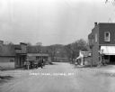
| Date: | |
|---|---|
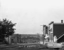
| Description: | A view down Main Street. Shops are on either side of the street. Farmer's Bank is down the hill on the right. |
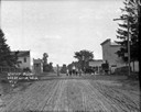
| Date: | 1913 |
|---|---|
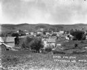
| Description: | Elevated view from hill of the town and hills in the distance. |

| Date: | 1922 |
|---|---|
| Description: | View down an unpaved street in a residential area, and storefronts further down. Near a garage on the right is a horse-drawn wagon and automobile. Two men ... |
| Date: | 02 02 1978 |
|---|---|
| Description: | "Groundhog Day... A view from the water tower, looking northwest. The 20mm lens provides a very wide angle of view." |
| Date: | |
|---|---|
| Description: | View down middle of road towards two corner shops across from one another. On the left, the store's sign reads, "Hot lunches." Two men pose outside in fron... |

| Date: | |
|---|---|
| Description: | View of automobiles driving on a street, entering the city. The Theresa water tower can be seen on the left. |
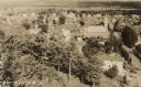
| Date: | 1932 |
|---|---|
| Description: | Aerial view of town looking down from hill lined with trees. In the foreground railroad tracks cross a road. A church building and numerous dwellings are a... |

| Date: | |
|---|---|
| Description: | View over town, including hotel and church, towards the Mississippi River. The far shoreline and bluffs are in the distance. |
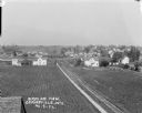
| Date: | 1912 |
|---|---|
| Description: | Elevated view of town with farm fields in the foreground, and low, rolling hills in the background. There is a church steeple in the far background on the ... |

| Date: | 1926 |
|---|---|
| Description: | View from hill looking down at homes and businesses in town. A bridge goes over the Kickapoo River. The depot and railroad tracks and Main Street are behin... |
| Date: | |
|---|---|
| Description: | View down hill towards Stoddard, with the Mississippi River and hills in the background. The German Lutheran Church is in the foreground, and there are rai... |
| Date: | 1916 |
|---|---|
| Description: | View down middle of unpaved street towards six children standing in the middle. There is a storefront on the right, with an automobile and a horse and bugg... |

| Date: | 1908 |
|---|---|
| Description: | Elevated photographic postcard view of town showing homes and businesses. A windmill is in the foreground. The school is on the far edge of town on the lef... |
If you didn't find the material you searched for, our Library Reference Staff can help.
Call our reference desk at 608-264-6535 or email us at:
