Filter: Categories of Wisconsin Historical Images
Filter: Subject of Fields (Agriculture)
Filter: Subject of land use
Filter: Subject of cities and towns
Filter: Categories of Wisconsin Historical Images
Filter: Subject of Fields (Agriculture)
Filter: Subject of land use
Filter: Subject of cities and towns

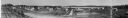
| Date: | 1873 |
|---|---|
| Description: | Main Street, with its dirt, ruts, cows (and presumably manure), but wide enough for easy hitching of wagons and teams. |
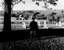
| Date: | |
|---|---|
| Description: | Charles Green, the last survivor of the African American colony at Pleasant Ridge (near Lancaster, WI) looks out over the community graveyard. |
| Date: | 1916 |
|---|---|
| Description: | Panoramic view of the Wingra area from the railroad tracks north of Gregory Street. Looking towards Lake Wingra, across Monroe Street. |

| Date: | 1860 |
|---|---|
| Description: | A general view of the Lane residence, which is the birthplace of Carrie Lane, later Carrie Chapman Catt, noted woman suffrage leader. |

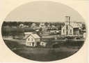
| Date: | 1910 |
|---|---|
| Description: | View of La Pointe taken from Big Bay Road on Madeline Island. |
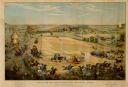
| Date: | 1886 |
|---|---|
| Description: | Color lithographed color advertising poster showing a McCormick grain binder at the Civil War battle of Gettysburg. The poster was based on a cyclorama by ... |
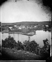
| Date: | 1875 |
|---|---|
| Description: | A view of the village from a nearby bluff across a pond. Men, women and children, standing spaced apart, are posing in the field near the pond. |
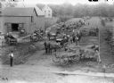
| Date: | |
|---|---|
| Description: | Elevated view of a parade of farmers and young children with horse-drawn wagons picking up their new McCormick machinery. They are parked along a rural dir... |

| Date: | 1886 |
|---|---|
| Description: | Cover of an advertising brochure for the Milwaukee Harvester Company featuring a color chromolithograph illustration of a farmer in a field operating a hor... |

| Date: | 1874 |
|---|---|
| Description: | Bird's-eye map of Chippewa Falls. |

| Date: | 1881 |
|---|---|
| Description: | Bird's-eye map of Milton Junction. |
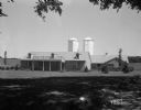
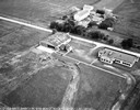
| Date: | 06 30 1944 |
|---|---|
| Description: | Rennebohm Farm buildings, with house in foreground and barn and silos in background, located five miles from the Capitol, 3787 Highway 151 between Madison ... |
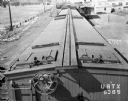
| Date: | 06 22 1943 |
|---|---|
| Description: | Elevated view of the top of an Oscar Mayer refrigerated railroad car, Chicago & Northwestern #URTX 5365 with a view of the Oscar Mayer rail yards. There is... |
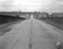
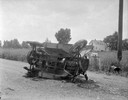
| Date: | 11 08 1928 |
|---|---|
| Description: | Stretch of paved rural highway featuring a proprietary centerline joint, looking towards Mount Horeb from the east. |

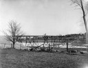
| Date: | 05 25 1928 |
|---|---|
| Description: | ESBMA (East Side Business Men's Association) men clearing area for playground at Burr Jones Field at 1800 E. Washington Street. |
| Date: | |
|---|---|
| Description: | View across field towards the railroad bridge, seen with the construction almost completed. A man is standing in the middle of the bridge, and two or three... |
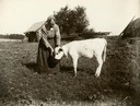
| Date: | 1905 |
|---|---|
| Description: | Woman feeding calf from a bucket. |
If you didn't find the material you searched for, our Library Reference Staff can help.
Call our reference desk at 608-264-6535 or email us at: