Filter: Categories of Wisconsin Historical Images
Filter: Subject of Fields (Agriculture)
Filter: Subject of land use, rural
Filter: Subject of aerial photographs
Filter: Categories of Wisconsin Historical Images
Filter: Subject of Fields (Agriculture)
Filter: Subject of land use, rural
Filter: Subject of aerial photographs

| Date: | 1956 |
|---|---|
| Description: | Aerial view of the new Madison television facility, WISC-TV (Channel 3), showing the transmitting tower in construction. The location is to the southwest,... |

| Date: | |
|---|---|
| Description: | Aerial view of a train crossing the East River in a rural community south of Green Bay. Some buildings are visible to the right and the background of the i... |

| Date: | 1957 |
|---|---|
| Description: | Aerial view of Yellowstone Lake and surrounding countryside. |

| Date: | 10 1928 |
|---|---|
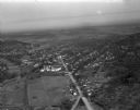
| Description: | Aerial view of Sun Prairie, including the central business district, residences, and the surrounding countryside stretching to the horizon. |
| Date: | 1930 |
|---|---|
| Description: | Aerial view of the Lake Delview Hotel, the golf course, and the surrounding countryside. |

| Date: | 1960 |
|---|---|
| Description: | Aerial view of the construction of the interstate highway near Mirror Lake, showing only the early stages of the bridge construction. |

| Date: | 02 09 1949 |
|---|---|
| Description: | Three aerial views of the John Fluckiger farm and farm buildings amid snow-covered fields near Verona, operated by son Ivan Fluckiger. |

| Date: | 02 09 1949 |
|---|---|
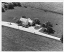
| Description: | One of four aerial views of the Edwin Blaney farm and farm buildings surrounded by snow-covered fields. Four miles south of Madison and a mile west of U.S.... |
| Date: | 03 28 1949 |
|---|---|
| Description: | Aerial photographs of Richland Center, Wisconsin. |

| Date: | 1950 |
|---|---|
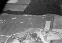
| Description: | Aerial view of a farm and surrounding fields farmed with the contour method. Shocks of grain dot several of the fields. |
| Date: | |
|---|---|
| Description: | Hand-tinted aerial photograph of the Apps Farm in the Wild Rose vicinity. |

| Date: | 1954 |
|---|---|
| Description: | North Central Airlines DC-3 airplane in flight. |

| Date: | 1960 |
|---|---|
| Description: | Aerial view of rural landscape with suburban construction in foreground. Cottage Grove Road is at left with the newly constructed Acewood Boulevard crossin... |

| Date: | 1948 |
|---|---|
| Description: | Aerial view of a farm in mid-winter. Snow blankets the ground and some of the buildings. An orchard is in the foreground. |
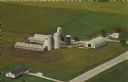
| Date: | 12 14 1972 |
|---|---|
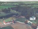
| Description: | Text on the reverse reads: "Mayer Farms. Dick and Fritz Mayer Families. Registered Holsteins. Visitors Always Welcome. Located 2 miles south of Slinger, Wi... |
If you didn't find the material you searched for, our Library Reference Staff can help.
Call our reference desk at 608-264-6535 or email us at: