 Filter: Categories of Wisconsin Historical Images
Filter: Subject of Fields (Agriculture)
Filter: Subject of landforms
Filter: Subject of land
Filter: Categories of Wisconsin Historical Images
Filter: Subject of Fields (Agriculture)
Filter: Subject of landforms
Filter: Subject of land

| Date: | 1958 |
|---|---|
| Description: | Aerial view of contour strip farming with the Obert Olstad farm in foreground. The Carl Backum farm is in the background. |
| Date: | 1875 |
|---|---|
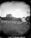
| Description: | View from a distance of a farm in a valley owned by Alex(ander?) Smith. There is a wooden fence in the foreground surrounding the farm. |
| Date: | 1945 |
|---|---|
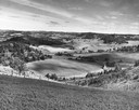
| Description: | Elevated view of Trempealeau County, south of Arcadia. |

| Date: | 12 01 1962 |
|---|---|
| Description: | A farm road between fields in late sunlight, looking towards Mounds Creek in the vicinity of CTH F. |

| Date: | 1874 |
|---|---|
| Description: | Bird's-eye map of Chippewa Falls. |
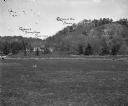
| Date: | 1876 |
|---|---|
| Description: | View of a farmstead with fences, haystacks and a wooden building. A man is in the background on top of McCord Rock, also called Devil's Chimney, Preacher'... |

| Date: | 1632 |
|---|---|
| Description: | The Wisconsin portion of Champlain's 1632 map, augmented since the previous one, for navigation according to the true Meridien, by Sieur de Champlain. The ... |

| Date: | 1900 |
|---|---|
| Description: | Elevated view of the brewery dwarfed by the overhead bluffs. The brewery was built by William Schmitz. George Scheibl ran the brewery from 1899 until his d... |

| Date: | |
|---|---|
| Description: | Elevated view from bluff of a house in Cassville surrounded by bluffs, trees and farmland. Railroad tracks run between the crops and the trees, and the Mis... |
| Date: | 1910 |
|---|---|
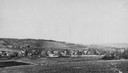
| Description: | View from hill looking down at Cross Plains. |
| Date: | 1901 |
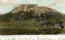
|---|---|
| Description: | Grand Dad Bluff in La Crosse with the Crusher building which was built in 1901 and burned in 1902. Caption reads: "Grand Dad Bluff, La Crosse, Wis." |

| Date: | 1909 |
|---|---|
| Description: | View from the University of Wisconsin service building smokestack of south Madison, including Mills Street, Mound Street, and the Greenbush. Lake Monona is... |

| Date: | 1900 |
|---|---|
| Description: | Elevated view of La Crosse. Caption reads: "Panorama of La Crosse, Wis. from Grand Dad's Bluff." |

| Date: | 11 1951 |
|---|---|
| Description: | Aerial view of US Highway 14 southeast of La Crosse descending into Mormon Coulee. The original caption of the print, which is undated, describes the road ... |
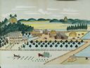
| Date: | 1875 |
|---|---|
| Description: | Seifert's watercolor is fairly large, measuring 27" wide by 21" high, and provides a detailed depiction of a nineteenth century Wisconsin farm. The small s... |
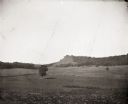
| Date: | 1900 |
|---|---|
| Description: | Distant view of Black Hawk Lookout near the Wisconsin River. There is an open field with a single tree and a fence in the foreground. |

| Date: | 10 1905 |
|---|---|
| Description: | Elevated view from Reservoir Bluff to the east of the town. The bluffs of Iowa can be seen in the distance. |
| Date: | 1900 |
|---|---|
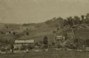
| Description: | Nelson Dewey farm, showing the house built on the site after Dewey's death. The original house built by Dewey burned in 1873. |
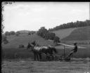
| Date: | 1899 |
|---|---|
| Description: | A man sporting a beard and wide-brimmed straw (?) hat is operating a mower pulled by two horses in a field. The field is on hilly terrain. A dirt road and ... |

| Date: | 1930 |
|---|---|
| Description: | A winter view of "The Three Chimneys" in the St. Peter sandstone formation. |
If you didn't find the material you searched for, our Library Reference Staff can help.
Call our reference desk at 608-264-6535 or email us at: