 Filter: Categories of Wisconsin Historical Images
Filter: Subject of Fields (Agriculture)
Filter: Subject of michigan, lake
Filter: Subject of bays
Filter: Categories of Wisconsin Historical Images
Filter: Subject of Fields (Agriculture)
Filter: Subject of michigan, lake
Filter: Subject of bays

| Date: | |
|---|---|
| Description: | Aerial view of harbors and bridge. Farm fields are on either side of the bridge. The city of Sturgeon Bay is in the distance. There are docks along the sho... |

| Date: | 1831 |
|---|---|
| Description: | This map shows the land that makes up Michigan, Wisconsin, Minnesota, Indiana, and parts of Canada. The Great Lakes are displayed prominently, along with s... |
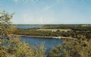
| Date: | 1957 |
|---|---|
| Description: | Elevated view of Little Sister Bay and the surrounding landscape. |
If you didn't find the material you searched for, our Library Reference Staff can help.
Call our reference desk at 608-264-6535 or email us at: