 Filter: Categories of Wisconsin Historical Images
Filter: Subject of Fields (Agriculture)
Filter: Subject of michigan, lake
Filter: Categories of Wisconsin Historical Images
Filter: Subject of Fields (Agriculture)
Filter: Subject of michigan, lake

| Date: | 1886 |
|---|---|
| Description: | Cover of an advertising brochure for the Milwaukee Harvester Company featuring a color chromolithograph illustration of a farmer in a field operating a hor... |

| Date: | 1858 |
|---|---|
| Description: | Elevated view from bluff looking down on city, with Lake Michigan in background. Detailed foreground with two boys playing with a grounded kite, while a ma... |

| Date: | 1632 |
|---|---|
| Description: | The Wisconsin portion of Champlain's 1632 map, augmented since the previous one, for navigation according to the true Meridien, by Sieur de Champlain. The ... |
| Date: | 1925 |
|---|---|
| Description: | Two young men pick berries in a field on a hill near Juddville. Chambers Island is seen on the horizon of the Green Bay. |
| Date: | 1921 |
|---|---|
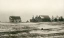
| Description: | View across snowy field of a shingled house, barn and other outbuildings standing empty near the shore of Lake Michigan at Newport Village. |

| Date: | 1930 |
|---|---|
| Description: | Aerial view, looking northeast, across Mud Lake with North Bay in the background, showing cultivated fields and wooded land. |

| Date: | 1930 |
|---|---|
| Description: | Aerial view of the northern tip of the Door Peninsula, looking north. Europe Lake is in the center, with Europe Bay to the right. Plum Island and Washingto... |

| Date: | 1930 |
|---|---|
| Description: | Aerial view looking northeast, with Rowley's Bay in the foreground. Europe Lake is to the left, with Europe Bay and Newport Bay separated by a narrow peni... |

| Date: | 1930 |
|---|---|
| Description: | Aerial view over northern Door County, looking northeast across Europe Lake and Europe Bay toward Plum and Washington Islands. Farm fields and orchards con... |

| Date: | 1930 |
|---|---|
| Description: | Aerial view, looking north, across the beach and pier on Europe Bay to Europe Lake and beyond to Washington Island. The land south (to the right) of Europe... |

| Date: | 1915 |
|---|---|
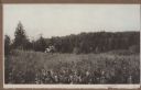
| Description: | A view, from above Juddville, looking north across a rocky meadow toward wooded bluffs near Fish Creek. A fence crosses the meadow and there is a saltbox-s... |
| Date: | 1909 |
|---|---|
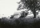
| Description: | Scene near what may be Coleman, perhaps on the shore of Green Bay on Lake Michigan. View through tall grass towards a man standing next to an automobile lo... |

| Date: | |
|---|---|
| Description: | Aerial view of harbors and bridge. Farm fields are on either side of the bridge. The city of Sturgeon Bay is in the distance. There are docks along the sho... |

| Date: | |
|---|---|
| Description: | Aerial view of harbor. In the foreground is a lighthouse and breakwaters. Bridges cross the harbor, and there are factory and industrial buildings near the... |

| Date: | 1937 |
|---|---|
| Description: | Pictorial map showing historical events and locations within the state of Wisconsin, as well as waterways and counties. Original caption on the bottom marg... |

| Date: | 1831 |
|---|---|
| Description: | This map shows the land that makes up Michigan, Wisconsin, Minnesota, Indiana, and parts of Canada. The Great Lakes are displayed prominently, along with s... |
| Date: | 1957 |
|---|---|
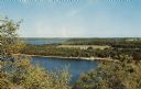
| Description: | Elevated view of Little Sister Bay and the surrounding landscape. |
If you didn't find the material you searched for, our Library Reference Staff can help.
Call our reference desk at 608-264-6535 or email us at: