Filter: Categories of Wisconsin Historical Images
Filter: Subject of Fields (Agriculture)
Filter: Subject of persons
Filter: Subject of aerial photographs
Filter: Categories of Wisconsin Historical Images
Filter: Subject of Fields (Agriculture)
Filter: Subject of persons
Filter: Subject of aerial photographs

| Date: | 1950 |
|---|---|
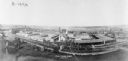
| Description: | Aerial view of the Frank Lloyd-Wright-dsigned Unitarian Church under construction and the Veteran's Administration Hospital, also under construction, to th... |

| Date: | 1950 |
|---|---|
| Description: | Aerial view of a farm and surrounding fields farmed with the contour method. Shocks of grain dot several of the fields. |

| Date: | 1955 |
|---|---|
| Description: | An aerial view of Middleton. In the foreground is a baseball field, and beyond are houses, woods, fields, and Lake Mendota. |

| Date: | |
|---|---|
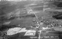
| Description: | Aerial view of Plymouth. Published by McLaughlin Aerial Surveys. |
| Date: | 1931 |
|---|---|
| Description: | Aerial view taken from an airplane overlooking the town of Mason. Farm fields, roads, trees, houses and other buildings are visible. |
| Date: | 05 1948 |
|---|---|
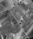
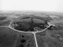
| Description: | "This shows where Cty Trk P & Hochheim Rd intersect. A small creek cuts through the Wm Kemp Farm." |
| Date: | 09 1996 |
|---|---|
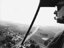
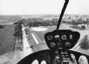
| Description: | "When Pioneer Days was celebrated, visitors were given the chance to view the community from a helicopter." |

| Date: | 09 1996 |
|---|---|
| Description: | "Theresa's Bonduel & Wisconsin Streets from the air." |
| Date: | 09 1996 |
|---|---|
| Description: | "As you look north, North Pole Road intersects DD. At the right is Theresa Station." |
| Date: | 09 1996 |
|---|---|
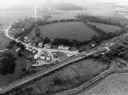
| Description: | "This is Theresa Station. Note the Rock River and Soo Line Railroad track." |
| Date: | 09 1996 |
|---|---|
| Description: | "As we approach Firemen's Park, we are at the end of our ride." |

| Date: | |
|---|---|
| Description: | Aerial view of Vieth's Park subdivision on the north shore of Lake Mendota. |

| Date: | |
|---|---|
| Description: | Aerial view of a WACO ASO (also known as J-5 Straightwing and Whirlwind Waco) in flight. Two men are sitting in the front open cockpit, and one man is sitt... |
| Date: | |
|---|---|
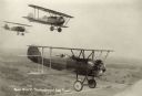
| Description: | Aerial view of three WACO ATO (10-T Taperwing) biplanes in flight. The wing identifiers of the two planes furthest to the right read: "7527" and "5673" (le... |

| Date: | |
|---|---|
| Description: | Aerial Ektachrome postcard of the Holy Hill shrine and surrounding landscape. Text on reverse reads: "Holy Hill Shrine of Mary — Help of Christians U.S... |
If you didn't find the material you searched for, our Library Reference Staff can help.
Call our reference desk at 608-264-6535 or email us at: