Filter: Categories of Wisconsin Historical Images
Filter: Subject of Fields (Agriculture)
Filter: Subject of rivers
Filter: Subject of barns
Filter: Categories of Wisconsin Historical Images
Filter: Subject of Fields (Agriculture)
Filter: Subject of rivers
Filter: Subject of barns

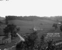
| Date: | 1914 |
|---|---|
| Description: | Slightly elevated view of a man driving three women in an International Model M truck along a rural road. In the background is a valley with farm buildings... |
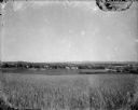
| Date: | 1920 |
|---|---|
| Description: | A view of a rolling rural landscape, most likely in Sauk County. In the far distance are houses and farm buildings, a church and a larger building, center ... |

| Date: | |
|---|---|
| Description: | Colorized postcard of the horseshoe curve of railroad tracks. Elevated view of the railroad tracks with train snaking past a farmhouse and a bridge suspend... |
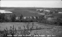
| Date: | |
|---|---|
| Description: | Elevated view of farmland. In the bottom-left center, there is a structure with a bell tower near a dirt road. In the center there is a similar building. T... |
| Date: | 1935 |
|---|---|
| Description: | View from hill of Iron River winding through countryside of farms. |
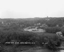
| Date: | 1929 |
|---|---|
| Description: | Elevated view of town looking down a hill. In the foreground is a river with trees along the bank. On the other side of the river is a factory with industr... |
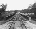
| Date: | 1929 |
|---|---|
| Description: | View down the railroad tracks across the bridge. On the far side are barns and industrial buildings among trees. |
| Date: | 02 02 1978 |
|---|---|
| Description: | "Water tower view, looking due west." |

| Date: | 02 16 1978 |
|---|---|
| Description: | "The long lens compresses this view from the frozen Rock River in the foreground, the Catholic cemetery, and the Haag farm buildings in the distance." |

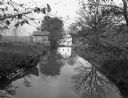
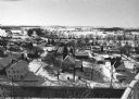
| Date: | 1910 |
|---|---|
| Description: | Elevated view over the ox-bow of the Bark River in early morning. Buildings, dwellings and barns are in the foreground at the bottom of the hill, and a bri... |

| Date: | 1862 |
|---|---|
| Description: | This map shows landownership on a military reserve, private claims, buildings (including Fort Howard and U.S. sawmill), swamps, public barns and fields, an... |
If you didn't find the material you searched for, our Library Reference Staff can help.
Call our reference desk at 608-264-6535 or email us at: