 Filter: Categories of Wisconsin Historical Images
Filter: Subject of Fields (Agriculture)
Filter: Subject of rivers
Filter: Subject of service industries
Filter: Categories of Wisconsin Historical Images
Filter: Subject of Fields (Agriculture)
Filter: Subject of rivers
Filter: Subject of service industries

| Date: | 1874 |
|---|---|
| Description: | Bird's-eye map of Chippewa Falls. |

| Date: | 1878 |
|---|---|
| Description: | Bird's-eye map of Kewaskum. Includes a list of hotels, churches, post office, railroad depot, etc. |
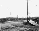
| Date: | |
|---|---|
| Description: | View of Lovers Lane, which a dirt road with a sidewalk and bridge on the right. There are power lines in the foreground, and a town in the background. Ther... |

| Date: | 04 1951 |
|---|---|
| Description: | "The camera looks south on the bridge on North Pole Rd." |

| Date: | |
|---|---|
| Description: | View over town, including hotel and church, towards the Mississippi River. The far shoreline and bluffs are in the distance. |
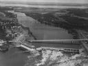
| Date: | 1950 |
|---|---|
| Description: | Aerial view of a hydroelectric power plant owned by Northern States Power Company located on the Chippewa River. A highway bridge and a railroad bridge spa... |
If you didn't find the material you searched for, our Library Reference Staff can help.
Call our reference desk at 608-264-6535 or email us at: