 Filter: Categories of Wisconsin Historical Images
Filter: Subject of Fields (Agriculture)
Filter: Subject of rivers
Filter: Categories of Wisconsin Historical Images
Filter: Subject of Fields (Agriculture)
Filter: Subject of rivers

| Date: | 1910 |
|---|---|
| Description: | Elevated view over the ox-bow of the Bark River in early morning. Buildings, dwellings and barns are in the foreground at the bottom of the hill, and a bri... |

| Date: | 1913 |
|---|---|
| Description: | View from riverbank looking down towards two girls standing in the middle of a bridge along a road. They are looking over the railing at the water below. F... |
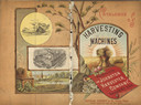
| Date: | 1886 |
|---|---|
| Description: | Front and back cover of a catalog for harvesting machines. The cover features a color illustration of shocks of hay in a field surrounded by sun rays in th... |
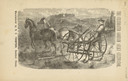
| Date: | 1880 |
|---|---|
| Description: | Front page of booklet with an engraving of a man with a team of two horses in a field with the "Celebrated Gorham Sulky Cultivator." |

| Date: | 1919 |
|---|---|
| Description: | Brochure cover of Diamond Plows, Sulky & Gang, featuring an illustration of a landscape. |

| Date: | 1910 |
|---|---|
| Description: | Aerial view along river toward Darlington. Caption reads: "Bird's-Eye View, Darlington, Wis." |

| Date: | 1900 |
|---|---|
| Description: | View down hill towards men standing near a horse-drawn carriage on the shoreline of a river. On the other side of the river is a high stone wall with grass... |

| Date: | |
|---|---|
| Description: | Aerial view of harbor. In the foreground is a lighthouse and breakwaters. Bridges cross the harbor, and there are factory and industrial buildings near the... |

| Date: | |
|---|---|
| Description: | View down field towards a river on the left, a board fence at the end of the field with trees behind it, and cattle on the right. |

| Date: | 1900 |
|---|---|
| Description: | View from hill looking down towards valley with fields and a river. |

| Date: | |
|---|---|
| Description: | Landscape view down hill towards valley, with a railroad bridge over a river. Pasture lands are in the distance. |

| Date: | 1862 |
|---|---|
| Description: | This map shows landownership on a military reserve, private claims, buildings (including Fort Howard and U.S. sawmill), swamps, public barns and fields, an... |

| Date: | 1900 |
|---|---|
| Description: | View across field towards a river with a bridge on the right. On the far side of the river is a flock of animals. Farther in the distance are farm building... |

| Date: | 1947 |
|---|---|
| Description: | View from hill looking down across fields at the property of Charles Grignon. Grignon Mansion in the background among trees, and beyond is the Fox River. O... |

| Date: | 1937 |
|---|---|
| Description: | Pictorial map showing historical events and locations within the state of Wisconsin, as well as waterways and counties. Original caption on the bottom marg... |

| Date: | 1831 |
|---|---|
| Description: | This map shows the land that makes up Michigan, Wisconsin, Minnesota, Indiana, and parts of Canada. The Great Lakes are displayed prominently, along with s... |

| Date: | 1907 |
|---|---|
| Description: | Trees are reflected in the calm waters of the Fox River just below the lock and dam at Montello. Fences are on each side of the river. The printed inscript... |

| Date: | |
|---|---|
| Description: | Aerial view looking down at a Keystone K-78 "Patrician" in flight. The "Patrician" is a twenty-passenger monoplane powered by three Wright Cyclone engines.... |

| Date: | 1922 |
|---|---|
| Description: | Elevated view of Chaseburg and the surrounding landscape, with a river and bluffs in the background. Caption reads: "Chaseburg, Wis." |

| Date: | |
|---|---|
| Description: | Elevated view from a hill of a lake or river surrounded by fields and hills. The water is either marshy, or has been flooded, as trees and plants are growi... |
If you didn't find the material you searched for, our Library Reference Staff can help.
Call our reference desk at 608-264-6535 or email us at: