 Filter: Categories of Wisconsin Historical Images
Filter: Subject of Fields (Agriculture)
Filter: Subject of rivers
Filter: Year of 1800-1899
Filter: Categories of Wisconsin Historical Images
Filter: Subject of Fields (Agriculture)
Filter: Subject of rivers
Filter: Year of 1800-1899

| Date: | 1871 |
|---|---|
| Description: | Advertising poster for the Dodge improved combined self raking reaper and mower featuring a color illustration of a well-dressed farmer on the machine pull... |
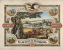
| Date: | 1876 |
|---|---|
| Description: | Color chromolithograph illustration advertising poster for the Marsh Harvester, produced by Gammon and Deering Company. Printed by Charles Shober & Co., Ch... |
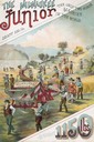
| Date: | 1887 |
|---|---|
| Description: | Back cover of an advertising brochure for the Milwaukee Harvester Company featuring a color chromolithograph illustration of the Milwaukee Junior binder, t... |

| Date: | 1874 |
|---|---|
| Description: | Bird's-eye map of Chippewa Falls. |

| Date: | 1878 |
|---|---|
| Description: | Bird's-eye map of Kewaskum. Includes a list of hotels, churches, post office, railroad depot, etc. |
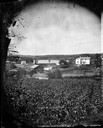
| Date: | 1875 |
|---|---|
| Description: | View, through a cornfield, of people, a store, a sawmill and wagons. Moscow was platted in 1850 by an Englishman, Chauncy Smith, who dammed the Bluemound ... |
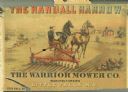
| Date: | 1890 |
|---|---|
| Description: | Advertisement for the Randall Harrow, manufactured by the Warrior Mower Company. Features a color illustration of a farmer using the harrow in a field. |

| Date: | 1898 |
|---|---|
| Description: | View from water tower, showing the grove where Black Hawk's pursuers were supposed to have camped in 1832. The group of men in the foreground are digging f... |
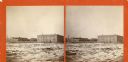
| Date: | 1870 |
|---|---|
| Description: | Stereograph view across what may be the Fox River, or a field with snow on the ground. There are large buildings behind a fence in the background. Caption ... |
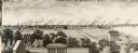
| Date: | 1880 |
|---|---|
| Description: | Illustration of an elevated view over rooftops looking towards Oshkosh. There are chimneys along the horizon with smoke rising into the sky. A river is alo... |
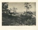
| Date: | 1866 |
|---|---|
| Description: | View of the Chattanooga Valley and a river from Lookout Mountain. Trees are in the foreground, and a city is in the background across the river. Plate 1... |

| Date: | 1899 |
|---|---|
| Description: | Overhead map of the Stanley McCormick's Riven Rock estate in El Montecito, Santa Barbara, California. The map shows the placement of dwellings and fields, ... |
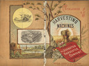
| Date: | 1886 |
|---|---|
| Description: | Front and back cover of a catalog for harvesting machines. The cover features a color illustration of shocks of hay in a field surrounded by sun rays in th... |
| Date: | 1880 |
|---|---|
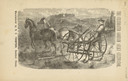
| Description: | Front page of booklet with an engraving of a man with a team of two horses in a field with the "Celebrated Gorham Sulky Cultivator." |

| Date: | 1862 |
|---|---|
| Description: | This map shows landownership on a military reserve, private claims, buildings (including Fort Howard and U.S. sawmill), swamps, public barns and fields, an... |

| Date: | 1831 |
|---|---|
| Description: | This map shows the land that makes up Michigan, Wisconsin, Minnesota, Indiana, and parts of Canada. The Great Lakes are displayed prominently, along with s... |
If you didn't find the material you searched for, our Library Reference Staff can help.
Call our reference desk at 608-264-6535 or email us at:
