Filter: Categories of Wisconsin Historical Images
Filter: Subject of Fields (Agriculture)
Filter: Subject of roads
Filter: Subject of hills
Filter: Categories of Wisconsin Historical Images
Filter: Subject of Fields (Agriculture)
Filter: Subject of roads
Filter: Subject of hills

| Date: | 1958 |
|---|---|
| Description: | Aerial view of contour strip farming with the Obert Olstad farm in foreground. The Carl Backum farm is in the background. |

| Date: | 12 01 1962 |
|---|---|
| Description: | A farm road between fields in late sunlight, looking towards Mounds Creek in the vicinity of CTH F. |

| Date: | 1878 |
|---|---|
| Description: | Bird's-eye map of Kewaskum. Includes a list of hotels, churches, post office, railroad depot, etc. |
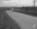
| Date: | 11 08 1928 |
|---|---|
| Description: | Stretch of paved rural highway near Mount Horeb featuring a proprietary centerline joint. |
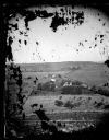
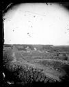
| Date: | |
|---|---|
| Description: | View from hill over a valley dotted with farmsteads and a meandering stream in the foreground. A group of three or four people are posing at the opposite s... |
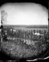
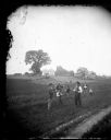
| Date: | 1873 |
|---|---|
| Description: | View of several farms, including Burton's, Fitlen's and Rustebakke's. Field arrangements and fencing patterns are evident. A man is walking along the bott... |
| Date: | 1873 |
|---|---|
| Description: | View down a rocky rural lane near West Blue Mounds. Zigzag stake and rider split-rail fencing enclose a farmstead, which includes a barn, a frame house, ha... |
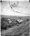
| Date: | |
|---|---|
| Description: | View from hill overlooking a farmstead at the base of the hill with a windmill and a pond. On the right in the foreground, two men, one sitting, one standi... |
| Date: | |
|---|---|
| Description: | In this tableau, men and boys stand at the edge of the field in elaborate and fanciful poses. The man on the left holds a hoe and cake while the one on the... |
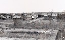
| Date: | 1900 |
|---|---|
| Description: | View from hill across field towards farmhouses, dwellings and churches along a road. In the foreground are stumps. Caption reads: "Big Falls, Wis." |
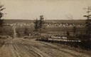
| Date: | 1908 |
|---|---|
| Description: | Caption reads: "Crandon—Wis. From Teachworth Hill". |

| Date: | 05 10 1928 |
|---|---|
| Description: | The Lutheran Church and buildings, seen from Lutheran Church Hill. |
| Date: | 1860 |
|---|---|
| Description: | Elevated view of multiple buildings in Cross Plains from Lutheran Church Hill. Many roads and fences cross the fields. Wooded hills are in the background. ... |
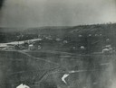
| Date: | 1912 |
|---|---|
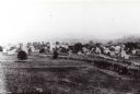
| Description: | Elevated view of Wausau from the edge of town looking toward residences and businesses. Hills are in the far background. |
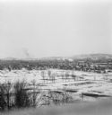
| Date: | 1912 |
|---|---|
| Description: | Winter view over fields of town with hills in the far background. |

| Date: | 11 1951 |
|---|---|
| Description: | Aerial view of US Highway 14 southeast of La Crosse descending into Mormon Coulee. The original caption of the print, which is undated, describes the road ... |

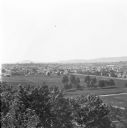
| Date: | 10 1905 |
|---|---|
| Description: | Elevated view from Reservoir Bluff to the east of the town. The bluffs of Iowa can be seen in the distance. |
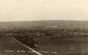
| Date: | 1930 |
|---|---|
| Description: | Elevated view of the north side of town, from high on the bluff. Caption reads: "'Birdseye' No. End Prairie Du Chien, Wis." |
If you didn't find the material you searched for, our Library Reference Staff can help.
Call our reference desk at 608-264-6535 or email us at: