Filter: Categories of Wisconsin Historical Images
Filter: Subject of Fields (Agriculture)
Filter: Subject of roads
Filter: Subject of streets
Filter: Categories of Wisconsin Historical Images
Filter: Subject of Fields (Agriculture)
Filter: Subject of roads
Filter: Subject of streets

| Date: | 1956 |
|---|---|
| Description: | Aerial view of the South Park Street interchange. |

| Date: | 1915 |
|---|---|
| Description: | View down road of a group of prisoners wearing striped jumpsuits doing road work while supervisors look on. A horse-drawn wagon is parked near a fence, and... |
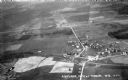
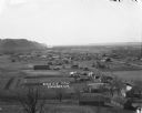
| Date: | 1931 |
|---|---|
| Description: | Aerial view taken from an airplane overlooking the town of Mason. Farm fields, roads, trees, houses and other buildings are visible. |
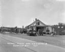
| Date: | 1929 |
|---|---|
| Description: | Exterior view from road of gas station and "dine and dance" restaurant on Highway US-18/US-12, outside the Triangle Tourist Park. The establishment offers ... |
| Date: | 02 02 1978 |
|---|---|
| Description: | "The camera looks to the new subdivision and beyond." |

| Date: | 1925 |
|---|---|
| Description: | Elevated view of Mount Vernon from the a grassy hill. |

| Date: | 09 1996 |
|---|---|
| Description: | "Theresa's Bonduel & Wisconsin Streets from the air." |

| Date: | 1900 |
|---|---|
| Description: | Elevated view over city. A church is in the middle foreground, and the Mississippi River and far shoreline is in the background. On the right side is a dir... |
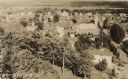
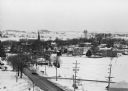
| Date: | 1932 |
|---|---|
| Description: | Aerial view of town looking down from hill lined with trees. In the foreground railroad tracks cross a road. A church building and numerous dwellings are a... |
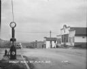
| Date: | 1929 |
|---|---|
| Description: | View from town of the road leading out of town towards fields and low hills. On the left at the curb is a fire hydrant and a Red Crown Gasoline gas pump. A... |
| Date: | |
|---|---|
| Description: | View down hill towards Stoddard, with the Mississippi River and hills in the background. The German Lutheran Church is in the foreground, and there are rai... |

| Date: | 1929 |
|---|---|
| Description: | Elevated view of Viola and neighboring farms in a valley surrounded by rolling hills. |

| Date: | 1908 |
|---|---|
| Description: | Elevated photographic postcard view of town showing homes and businesses. A windmill is in the foreground. The school is on the far edge of town on the lef... |

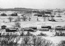
| Date: | 1956 |
|---|---|
| Description: | Aerial view of residential homes, farmland and streets. |

| Date: | 1955 |
|---|---|
| Description: | Aerial view, looking west from over Hoyt Park toward Midvale Boulevard. |

| Date: | 1776 |
|---|---|
| Description: | Fairly detailed map of New York City and parts of Long Island. It shows streets, roads, wharves, ferries, ship yards, Fort George and the battery, public b... |
If you didn't find the material you searched for, our Library Reference Staff can help.
Call our reference desk at 608-264-6535 or email us at: