Visit our other Wisconsin Historical Society websites!
 Filter: Categories of Wisconsin Historical Images
Filter: Subject of Fields (Agriculture)
Filter: Subject of transportation
Filter: Categories of Wisconsin Historical Images
Filter: Subject of Fields (Agriculture)
Filter: Subject of transportation

| Date: | 1878 |
|---|---|
| Description: | Bird's-eye map of Kewaskum. Includes a list of hotels, churches, post office, railroad depot, etc. |

| Date: | 1881 |
|---|---|
| Description: | Bird's-eye map of Milton Junction. |
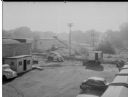
| Date: | 09 10 1945 |
|---|---|
| Description: | Elevated view of a Findorff truck and earthmover and Madison Sand and Gravel truck standing ready to excavate for an addition to the Red Dot Foods, Incorpo... |
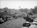
| Date: | 09 10 1945 |
|---|---|
| Description: | Elevated view of a Findorff truck and earthmover standing ready to excavate for an addition to the Red Dot Foods Incorporated potato chip factory, 1441 Eas... |
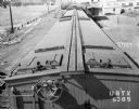
| Date: | 06 22 1943 |
|---|---|
| Description: | Elevated view of the top of an Oscar Mayer refrigerated railroad car, Chicago & Northwestern #URTX 5365 with a view of the Oscar Mayer rail yards. There is... |
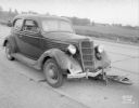
| Date: | 09 04 1938 |
|---|---|
| Description: | Accident scene on Highway 12-18 one-half mile east of the Dane County fairgrounds. Close-up of front of automobile, with bicycle under the car. Katherine B... |
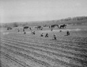
| Date: | 05 07 1937 |
|---|---|
| Description: | McKay Nursery field with men planting, and horse teams pulling cultivators. |

| Date: | 07 14 1935 |
|---|---|
| Description: | View across field towards a crowd at Royal Airport for Jimmie Allen model airplane flight contest and Air Circus at Royal Airport. |
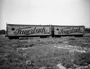
| Date: | 07 17 1934 |
|---|---|
| Description: | Two railroad freight cars with Fauerbach Beer signs covering their sides are parked outdoors on railroad tracks in a railroad yard. |
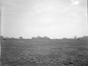
| Date: | 05 06 1934 |
|---|---|
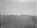
| Description: | Kroger air show. Panoramic view of the Madison Airport, end of North street at Coolidge, from across the field. |
| Date: | 05 06 1934 |
|---|---|
| Description: | Kroger air show, panoramic view of the Madison Airport, end of North street at Coolidge, from across the field. |
| Date: | 05 06 1934 |
|---|---|
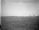
| Description: | Kroger air show, panoramic view of the Madison Airport, end of North street at Coolidge, and neighboring houses from across the field. |
| Date: | 04 15 1934 |
|---|---|
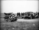
| Description: | Damaged automobiles of Leo Maly and August Steinhagen at scene of accident at Middleton Junction Road. Leo Maly was killed, his wife, Edna, and son, Paul, ... |

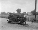
| Date: | 04 15 1934 |
|---|---|
| Description: | Auto accident involving Leo Maly and August Sternhagen vehicles, looking north, County Trunk M, between Speedway Road and Middleton Jct. Road. Leo Maly was... |
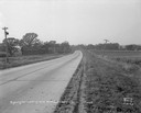
| Date: | 08 29 1933 |
|---|---|
| Description: | US Hwy 12 looking southwest, showing corn fields, McVicar Photo Service case, Sinclair sign and a good view of farm buildings in the background. |
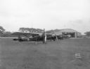
| Date: | 05 26 1932 |
|---|---|
| Description: | At Royal Airport, a line of airplanes are parked in a row in a field. In the background is a hangar with automobiles parked nearby. |
| Date: | 03 04 1932 |
|---|---|
| Description: | Piper Brothers farm scene, 4718 Odana Road near Midvale. |
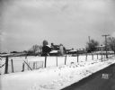
| Date: | 10 20 1931 |
|---|---|
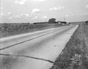
| Description: | Accident scene on Highway 51, rural area. Caption at bottom reads: "High #51 — Looking West — Northwest — October 20, 1931 2:00 P.M." |
If you didn't find the material you searched for, our Library Reference Staff can help.
Call our reference desk at 608-264-6535 or email us at: