Visit our other Wisconsin Historical Society websites!
 Filter: Categories of Wisconsin Historical Images
Filter: Subject of Fields (Agriculture)
Filter: Subject of trees
Filter: Subject of roads
Filter: Categories of Wisconsin Historical Images
Filter: Subject of Fields (Agriculture)
Filter: Subject of trees
Filter: Subject of roads

| Date: | 1873 |
|---|---|
| Description: | Main Street, with its dirt, ruts, cows (and presumably manure), but wide enough for easy hitching of wagons and teams. |
| Date: | 1906 |
|---|---|
| Description: | View down tree-lined country road near Wausau, taken by Dr. Joseph Smith, talented amateur photographer. It depicts women (probably members of his family) ... |

| Date: | 1958 |
|---|---|
| Description: | Aerial view of contour strip farming with the Obert Olstad farm in foreground. The Carl Backum farm is in the background. |

| Date: | 1956 |
|---|---|
| Description: | Aerial view of the South Park Street interchange. |

| Date: | 01 1934 |
|---|---|
| Description: | Aerial view of New Butler, in Waukesha County. |

| Date: | 1910 |
|---|---|
| Description: | View of La Pointe taken from Big Bay Road on Madeline Island. |
| Date: | 1923 |
|---|---|
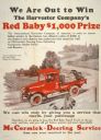
| Description: | Advertising poster for McCormick-Deering service featuring a color illustration of a "Red Baby" farm truck. The company offered a $1,000 prize to the deale... |

| Date: | |
|---|---|
| Description: | Advertising poster for International farm trucks and Farmall tractors. Features color illustrations of a K-1 truck and a Farmall H tractor. Includes the te... |
| Date: | 07 14 1926 |
|---|---|
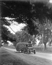
| Description: | International truck owned by Forestdale Farm hauling hay along a rural Louisiana road. |
| Date: | 1900 |
|---|---|
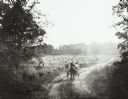
| Description: | Farmer pulling a McCormick Daisy reaper with two horses down a dirt country road. |

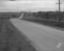
| Date: | 12 01 1962 |
|---|---|
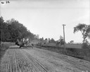
| Description: | A farm road between fields in late sunlight, looking towards Mounds Creek in the vicinity of CTH F. |
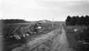
| Date: | 03 04 1932 |
|---|---|
| Description: | Piper Brothers farm scene, 4718 Odana Road near Midvale. |
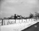
| Date: | 10 20 1931 |
|---|---|
| Description: | Accident scene on Highway 51, rural area. Caption at bottom reads: "High #51 — Looking West — Northwest — October 20, 1931 2:00 P.M." |
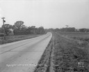
| Date: | 11 08 1928 |
|---|---|
| Description: | Stretch of paved rural highway near Mount Horeb featuring a proprietary centerline joint. |

| Date: | 1871 |
|---|---|
| Description: | Like many southeastern Wisconsin villages, Edgerton was settled by Yankee immigrants in the 1830s. Though this view gives no indication of it, by 1871 toba... |

| Date: | 1884 |
|---|---|
| Description: | Bird's-eye view drawing of the grounds of Villa Louis, the estate of the fur trading Dousman family. After the death of H. Louis Dousman's mother in 1882, ... |
| Date: | |
|---|---|
| Description: | Looking east at Terminal Moraine topography. View is down a dirt road with a house in the near background. |
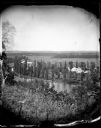
| Date: | |
|---|---|
| Description: | View from hill over a valley dotted with farmsteads and a meandering stream in the foreground. A group of three or four people are posing at the opposite s... |
If you didn't find the material you searched for, our Library Reference Staff can help.
Call our reference desk at 608-264-6535 or email us at:

