 Filter: Categories of Wisconsin Historical Images
Filter: Subject of Fields (Agriculture)
Filter: Subject of valleys
Filter: Subject of barns
Filter: Categories of Wisconsin Historical Images
Filter: Subject of Fields (Agriculture)
Filter: Subject of valleys
Filter: Subject of barns

| Date: | 05 10 1928 |
|---|---|
| Description: | The Lutheran Church and buildings, seen from Lutheran Church Hill. |

| Date: | 11 1951 |
|---|---|
| Description: | Aerial view of US Highway 14 southeast of La Crosse descending into Mormon Coulee. The original caption of the print, which is undated, describes the road ... |
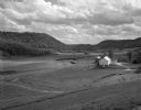
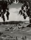
| Date: | 05 30 1962 |
|---|---|
| Description: | A country valley with a winding stream. A farmhouse with barn and silo are on the right. |

| Date: | 1900 |
|---|---|
| Description: | Landscape view of field, trees, and valley with farm buildings in background. A man is driving a horse-drawn reaper in a field in the foreground. |

| Date: | 1914 |
|---|---|
| Description: | Slightly elevated view of a man driving three women in an International Model M truck along a rural road. In the background is a valley with farm buildings... |

| Date: | |
|---|---|
| Description: | Elevated view of the countryside. Barns and dwellings are among fields and trees. |
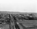
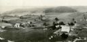
| Date: | 1909 |
|---|---|
| Description: | An elevated view of a town in the Wisconsin River Valley. Fields surround the town, and low hills are in the far background. |
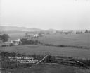
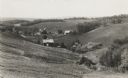
| Date: | |
|---|---|
| Description: | Rich Valley looking down at Mill Creek Valley. There are several farmhouses among the fields. |
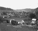
| Date: | |
|---|---|
| Description: | View down hill of town in a valley. There is open land, homes, barns and a bee farm. |

| Date: | |
|---|---|
| Description: | A man poses on a bluff overlooking a farm in the valley below. |

| Date: | |
|---|---|
| Description: | View from above of Elephant's Foot Rock with Woodstock in the valley below. |
| Date: | 1936 |
|---|---|
| Description: | View down hill towards valley of farming country in the “Coulee Region.” |
| Date: | 06 1976 |
|---|---|
| Description: | Caption on back of photograph: "Tom Nee farm, 3 miles SE of Richland Center. Looking west over Pine River Valley. Early summer, 1976. TION; RIE; S 1/2 NW 1... |

| Date: | 1928 |
|---|---|
| Description: | View down valley towards the back of the Lutheran Church and cemetery. Houses and barns are in the valley below, and more hills are in the far background. ... |

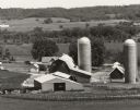
| Date: | 05 24 1961 |
|---|---|
| Description: | View across plowed field towards barn and farm buildings along CTH KP in the early morning. In the background are rolling hills and a ridge covered with tr... |

| Date: | |
|---|---|
| Description: | You came to know that book by its covered distance, well remembered by the measure of the trudging barefoot mile |
| Date: | 1930 |
|---|---|
| Description: | Aerial view of two farms, with fields and barns in a valley. This image appeared in Joseph Schafer's 1932 book The Wisconsin Lead Region, on a photo... |
| Date: | 1945 |
|---|---|
| Description: | Elevated view of a large farm in a valley. Caption reads: "Prosperous Sauk County Dairy farm — nestling in a fertile valley between timber-clad hills. Phot... |
If you didn't find the material you searched for, our Library Reference Staff can help.
Call our reference desk at 608-264-6535 or email us at:

