Filter: Categories of Wisconsin Historical Images
Filter: Subject of Fields (Agriculture)
Filter: Subject of water
Filter: Subject of cities and towns
Filter: Categories of Wisconsin Historical Images
Filter: Subject of Fields (Agriculture)
Filter: Subject of water
Filter: Subject of cities and towns
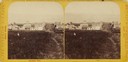
| Date: | 1916 |
|---|---|
| Description: | Panoramic view of the Wingra area from the railroad tracks north of Gregory Street. Looking towards Lake Wingra, across Monroe Street. |

| Date: | 1910 |
|---|---|
| Description: | View of La Pointe taken from Big Bay Road on Madeline Island. |
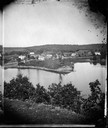
| Date: | 1875 |
|---|---|
| Description: | A view of the village from a nearby bluff across a pond. Men, women and children, standing spaced apart, are posing in the field near the pond. |

| Date: | 1950 |
|---|---|
| Description: | Aerial view of the Frank Lloyd-Wright-dsigned Unitarian Church under construction and the Veteran's Administration Hospital, also under construction, to th... |

| Date: | 1886 |
|---|---|
| Description: | Cover of an advertising brochure for the Milwaukee Harvester Company featuring a color chromolithograph illustration of a farmer in a field operating a hor... |

| Date: | 1874 |
|---|---|
| Description: | Bird's-eye map of Chippewa Falls. |

| Date: | 1878 |
|---|---|
| Description: | Bird's-eye map of Kewaskum. Includes a list of hotels, churches, post office, railroad depot, etc. |
| Date: | 1926 |
|---|---|
| Description: | Elevated view of Picnic Point on Lake Mendota from the University of Wisconsin-Madison Soils building. |

| Date: | 1883 |
|---|---|
| Description: | Bird's-eye map of Sauk City. |

| Date: | 1858 |
|---|---|
| Description: | Elevated view from bluff looking down on city, with Lake Michigan in background. Detailed foreground with two boys playing with a grounded kite, while a ma... |
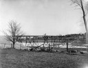
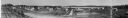
| Date: | |
|---|---|
| Description: | View across field towards the railroad bridge, seen with the construction almost completed. A man is standing in the middle of the bridge, and two or three... |

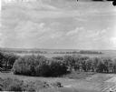
| Date: | 1874 |
|---|---|
| Description: | Distant view of the town from a hill with houses, garden plots, businesses and churches. |
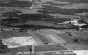
| Date: | 1947 |
|---|---|
| Description: | Aerial view of Lake Seven, surrounded by trees. Agricultural fields fill the foreground. Another lake is in the upper right. Caption reads: "Lake Seven Ade... |

| Date: | 1965 |
|---|---|
| Description: | Aerial view of downtown Big Falls and the Little Wolf River. The Little Wolf River is at lower right. |

| Date: | 1900 |
|---|---|
| Description: | Elevated view of the brewery dwarfed by the overhead bluffs. The brewery was built by William Schmitz. George Scheibl ran the brewery from 1899 until his d... |

| Date: | |
|---|---|
| Description: | Elevated view from bluff of a house in Cassville surrounded by bluffs, trees and farmland. Railroad tracks run between the crops and the trees, and the Mis... |
If you didn't find the material you searched for, our Library Reference Staff can help.
Call our reference desk at 608-264-6535 or email us at: