 Filter: Categories of Wisconsin Historical Images
Filter: Subject of Fields (Agriculture)
Filter: Subject of water
Filter: Subject of gardens
Filter: Categories of Wisconsin Historical Images
Filter: Subject of Fields (Agriculture)
Filter: Subject of water
Filter: Subject of gardens

| Date: | 1874 |
|---|---|
| Description: | Distant view of the town from a hill with houses, garden plots, businesses and churches. |
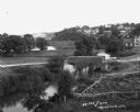
| Date: | |
|---|---|
| Description: | Elevated view of a stream with a dam and a bridge. There is a small fenced garden along the water. In the distance is a hillside with houses. |
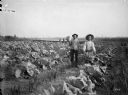
| Date: | 09 04 1895 |
|---|---|
| Description: | Men displaying produce, a large cabbage and a bushel of potatoes, while standing in the gardens of the Thayer farm. Cabbage, onion, currant, and raspberry ... |

| Date: | 1897 |
|---|---|
| Description: | Topographical map of Stanley McCormick's Riven Rock estate in El Montecito, Santa Barbara County, California. The map is identified as a map of a survey co... |

| Date: | |
|---|---|
| Description: | View over town, including hotel and church, towards the Mississippi River. The far shoreline and bluffs are in the distance. |

| Date: | |
|---|---|
| Description: | Elevated view of Cassville, including the town hall and St. Peter's Church. |

| Date: | 1776 |
|---|---|
| Description: | Fairly detailed map of New York City and parts of Long Island. It shows streets, roads, wharves, ferries, ship yards, Fort George and the battery, public b... |

| Date: | |
|---|---|
| Description: | Panoramic view of the nursery at Trout Lake. In the center are three men and a dog standing among seedlings in the nursery. There is a water tower and two ... |
If you didn't find the material you searched for, our Library Reference Staff can help.
Call our reference desk at 608-264-6535 or email us at: