 Filter: Categories of Wisconsin Historical Images
Filter: Subject of Fields (Agriculture)
Filter: Subject of wetlands
Filter: Categories of Wisconsin Historical Images
Filter: Subject of Fields (Agriculture)
Filter: Subject of wetlands
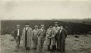
| Date: | 1914 |
|---|---|
| Description: | Group of well-dressed men standing in front of a plowed segment of Horicon Marsh. |

| Date: | 10 1914 |
|---|---|
| Description: | View of furrowed ground in Horicon Marsh and men on a tractor in the process of plowing a drained portion of the marsh. |
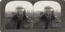
| Date: | |
|---|---|
| Description: | Stereograph showing workers digging a ditch with a tractor and laying drain tile. |

| Date: | |
|---|---|
| Description: | A bird's eye view overlooking the Mississippi River, sand bars, the railroad bridge, surrounding forests and wetlands. |

| Date: | 1862 |
|---|---|
| Description: | This map shows landownership on a military reserve, private claims, buildings (including Fort Howard and U.S. sawmill), swamps, public barns and fields, an... |

| Date: | 1970 |
|---|---|
| Description: | This map shows colored-coded land use with a legend in the bottom margin. Land classifications include: Year-round Residential (yellow), Seasonal Residenti... |
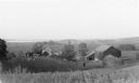
| Date: | 1935 |
|---|---|
| Description: | Elevated view from hill of chickens ranging near their coop behind a farmhouse and outbuildings on a tidy farm. There is a large barn on the right with two... |

| Date: | 1975 |
|---|---|
| Description: | View through snow-covered cattails after a winter snowfall towards a house on the left, and a barn and a silo on the right. |
If you didn't find the material you searched for, our Library Reference Staff can help.
Call our reference desk at 608-264-6535 or email us at: