 Filter: Categories of Wisconsin Historical Images
Filter: Subject of Fields (Agriculture)
Filter: Year of 1800-1899
Filter: Subject of roads
Filter: Categories of Wisconsin Historical Images
Filter: Subject of Fields (Agriculture)
Filter: Year of 1800-1899
Filter: Subject of roads

| Date: | 1873 |
|---|---|
| Description: | Main Street, with its dirt, ruts, cows (and presumably manure), but wide enough for easy hitching of wagons and teams. |

| Date: | 1878 |
|---|---|
| Description: | Bird's-eye map of Kewaskum. Includes a list of hotels, churches, post office, railroad depot, etc. |

| Date: | 1871 |
|---|---|
| Description: | Like many southeastern Wisconsin villages, Edgerton was settled by Yankee immigrants in the 1830s. Though this view gives no indication of it, by 1871 toba... |

| Date: | 1884 |
|---|---|
| Description: | Bird's-eye view drawing of the grounds of Villa Louis, the estate of the fur trading Dousman family. After the death of H. Louis Dousman's mother in 1882, ... |
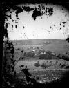
| Date: | 1873 |
|---|---|
| Description: | View of several farms, including Burton's, Fitlen's and Rustebakke's. Field arrangements and fencing patterns are evident. A man is walking along the bott... |
| Date: | 1873 |
|---|---|
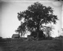
| Description: | View down a rocky rural lane near West Blue Mounds. Zigzag stake and rider split-rail fencing enclose a farmstead, which includes a barn, a frame house, ha... |
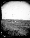
| Date: | 1876 |
|---|---|
| Description: | View, from above, of what may be the G. Gullockson farmstead. A frame house is in the left foreground, with a large group of men, women and children standi... |
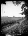
| Date: | 1875 |
|---|---|
| Description: | Elevated view of a man driving a horse-drawn wagon along a rural lane with a man walking in front on the left. In the background is a field, fences, farmho... |
| Date: | 1877 |
|---|---|
| Description: | A dirt road leads to Dr. Blake's (probably Samuel M.) frame house in Lodi or Prairie du Sac. A family is under a tree near a wooden fence. On the right is... |
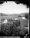
| Date: | 1860 |
|---|---|
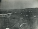
| Description: | Elevated view of multiple buildings in Cross Plains from Lutheran Church Hill. Many roads and fences cross the fields. Wooded hills are in the background. ... |

| Date: | 1897 |
|---|---|
| Description: | Ada Bass, the photographer's wife, leaning against a fence, next to daughter Everetta Bass as a young girl, along a dirt road. The photographer's sister, R... |

| Date: | 1866 |
|---|---|
| Description: | This detailed map shows the positions of the armies of the Ohio and Tennessee, Confederate lines, headquarters, "regimental camps at the date of the battle... |
| Date: | 05 1899 |
|---|---|
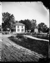
| Description: | View of William Krueger's house across the road from the Krueger farm. |
| Date: | 07 1897 |
|---|---|
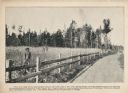
| Description: | A promotional card displaying a man in overalls standing by his large rye crops, near the road. The caption reads, "This view made from a photograph take... |

| Date: | 1895 |
|---|---|
| Description: | A bearded man stands in a vegetable garden holding a hat full of potatoes. There is a carriage with a team of horses on the road beside the garden. |

| Date: | 1897 |
|---|---|
| Description: | Topographical map of Stanley McCormick's Riven Rock estate in El Montecito, Santa Barbara County, California. The map is identified as a map of a survey co... |

| Date: | 1899 |
|---|---|
| Description: | Overhead map of the Stanley McCormick's Riven Rock estate in El Montecito, Santa Barbara, California. The map shows the placement of dwellings and fields, ... |
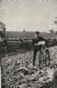
| Date: | 05 1892 |
|---|---|
| Description: | Frank Lenz posed with his bicycle on a badly neglected stretch of road. A split-rail fence encloses a field behind Lenz. |

| Date: | 06 1895 |
|---|---|
| Description: | View across field towards a large group of people in the distance walking behind a band along on a town street. Identified as the reunion of the Grand Army... |
If you didn't find the material you searched for, our Library Reference Staff can help.
Call our reference desk at 608-264-6535 or email us at:
