 Filter: Categories of Wisconsin Historical Images
Filter: Subject of Fields (Agriculture)
Filter: Year of 1900-1999
Filter: Subject of forests and forestry
Filter: Categories of Wisconsin Historical Images
Filter: Subject of Fields (Agriculture)
Filter: Year of 1900-1999
Filter: Subject of forests and forestry
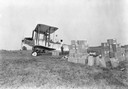
| Date: | 1925 |
|---|---|
| Description: | Loading an airplane with calcium arsenate in order to spray for the hemlock looper pest in Peninsula State Park. This is believed to be the first such use ... |

| Date: | 03 24 1913 |
|---|---|
| Description: | Picnic Point from the University Farm fields, now known as Observatory Hill. |
| Date: | 1930 |
|---|---|
| Description: | View from hill of a farm near a pond. There are homes along the far shoreline, and a lake and hills in the far background. |

| Date: | 1925 |
|---|---|
| Description: | Elevated view of Coon Valley from a hilltop. Trees are on either side of the frame. In the city, there is a cemetery, church, and field of crops. |
| Date: | 1925 |
|---|---|
| Description: | View of Coon Valley. Tall plants cover the lower portion of the frame. The landscape is includes homes, fields, and hills. |

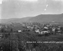
| Date: | 1915 |
|---|---|
| Description: | Elevated view of an urban main street in the foreground and a rural landscape in the background. |

| Date: | 1930 |
|---|---|
| Description: | Aerial view, looking northeast, across Mud Lake with North Bay in the background, showing cultivated fields and wooded land. |

| Date: | 1930 |
|---|---|
| Description: | Aerial view of the northern tip of the Door Peninsula, looking north. Europe Lake is in the center, with Europe Bay to the right. Plum Island and Washingto... |

| Date: | 1930 |
|---|---|
| Description: | Aerial view looking northeast, with Rowley's Bay in the foreground. Europe Lake is to the left, with Europe Bay and Newport Bay separated by a narrow peni... |

| Date: | 1930 |
|---|---|
| Description: | Aerial view over northern Door County, looking northeast across Europe Lake and Europe Bay toward Plum and Washington Islands. Farm fields and orchards con... |

| Date: | 1930 |
|---|---|
| Description: | Aerial view, looking north, across the beach and pier on Europe Bay to Europe Lake and beyond to Washington Island. The land south (to the right) of Europe... |
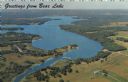
| Date: | 1967 |
|---|---|
| Description: | Aerial view of Bear Lake, with surrounding forests and farms. Caption reads: "Greetings from Bear Lake." |
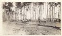
| Date: | 05 1911 |
|---|---|
| Description: | View across field towards a number of men working to clear a field. There is a team of horses pulling a plow to create a furrow, with a pine forest in the ... |

| Date: | 10 28 1936 |
|---|---|
| Description: | Outdoor group portrait of the state foresters at a meeting of the National Association of State Foresters in Wisconsin, October 28-30th. |

| Date: | 1950 |
|---|---|
| Description: | Aerial view of town, showing all of Lake Metonga in the background. Caption reads: "Greetings from Crandon, Wisconsin." |

| Date: | 05 28 1964 |
|---|---|
| Description: | Outdoor portrait of Jim Zimmerman, the school forester, standing in a field. |

| Date: | 1970 |
|---|---|
| Description: | This map shows colored-coded land use with a legend in the bottom margin. Land classifications include: Year-round Residential (yellow), Seasonal Residenti... |

| Date: | 09 14 1925 |
|---|---|
| Description: | Rear view of a man plowing rough land with a McCormick-Deering 15-30 tractor near forest. |
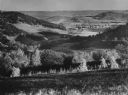
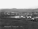
| Date: | 1953 |
|---|---|
| Description: | Elevated view along a hillside into a valley, with forests, buildings, and crop fields. Caption reads: "Barree Coulee from St. Joseph's Ridge, La Crosse Co... |

| Date: | 06 1952 |
|---|---|
| Description: | View across a prairie. Groves of trees, a herd of cattle, and a lake are in the distance. |
If you didn't find the material you searched for, our Library Reference Staff can help.
Call our reference desk at 608-264-6535 or email us at: