 Filter: Categories of Wisconsin Historical Images
Filter: Subject of Fire extinction
Filter: Subject of lakes
Filter: Categories of Wisconsin Historical Images
Filter: Subject of Fire extinction
Filter: Subject of lakes

| Date: | 1896 |
|---|---|
| Description: | A portion of John B. Heim's map of the Water Works System of Madison showing the size of the third Wisconsin Capitol (228' x 226') in comparison with the C... |

| Date: | 05 01 1952 |
|---|---|
| Description: | Two fire fighters are shown holding a hose with liquid shooting out of its nozzle while two other fire fighters look on. Behind them is a lake. |

| Date: | 1968 |
|---|---|
| Description: | The map shows fire towers, public camp grounds, roads, snow mobile & riding trails, trout lakes, foot trails, railroads, and National Forest boundaries. |

| Date: | 1937 |
|---|---|
| Description: | This map shows the Wisconsin Conservation Department forest protection divisions and the locations of state forests, national forests, Indian reservations,... |

| Date: | 05 01 1938 |
|---|---|
| Description: | This map shows the locations of Wisconsin Conservation Department forest protection districts and cooperative areas, state forests, national forests, India... |

| Date: | 1900 |
|---|---|
| Description: | This map of Three Lakes shows forest fire lookout towers, picnic grounds, an airport, roads, and railroad. The map features text boxes on the Village of Th... |
| Date: | 1915 |
|---|---|
| Description: | View from shoreline of Trout Lake of a group of six men posed with the pilot, possibly Jack Vilas, on an early seaplane or flying boat floating in the wate... |

| Date: | 1950 |
|---|---|
| Description: | Wisconsin Historical Marker near Trout Lake. The marker recognizes the first ever forest patrol flight. The marker text reads: "FIRST FOREST PATROL FLI... |

| Date: | 1955 |
|---|---|
| Description: | This map shows roads, golf courses, airports, fire towers, schools, camp grounds, rivers, streams, lakes, and railroads. The right margin of the map includ... |

| Date: | 1940 |
|---|---|
| Description: | This map shows lakes, roads, car trails, foot trails, railroads, resorts and camps, and fire towers. The map includes an inset location map and pictorial d... |

| Date: | 08 1940 |
|---|---|
| Description: | Two men, one wearing a pith helmet, are directing the stream from a fire hose over a body of water. There are several men in the background, some wearing W... |

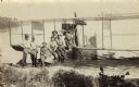
| Date: | |
|---|---|
| Description: | View from shoreline towards a group of men sitting and standing on a seaplane pulled up to the shoreline. The pilot is standing in the cockpit. List of na... |
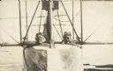
| Date: | 1915 |
|---|---|
| Description: | Caption reads: "Jack Vilas & Weaver." View along front of seaplane, with two men sitting inside. Both men have goggles. Water is in the background. |
If you didn't find the material you searched for, our Library Reference Staff can help.
Call our reference desk at 608-264-6535 or email us at: