 Filter: Categories of Wisconsin Historical Images
Filter: Subject of Fire extinction
Filter: Subject of land
Filter: Categories of Wisconsin Historical Images
Filter: Subject of Fire extinction
Filter: Subject of land

| Date: | 1896 |
|---|---|
| Description: | A portion of John B. Heim's map of the Water Works System of Madison showing the size of the third Wisconsin Capitol (228' x 226') in comparison with the C... |
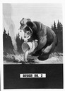
| Date: | 1944 |
|---|---|
| Description: | Poster design of Clarke-McNary Forest Protection Program depicting Smokey Bear pouring water on a campfire. |
| Date: | |
|---|---|
| Description: | Poster design from the Forest Protection Program depicting squirrels with the text: "Another Enemy To Conquer-Forest Fires-9 Out Of 10 Can BE Prevented". |

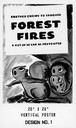
| Date: | |
|---|---|
| Description: | Poster design from the Forest Protection Program depicting squirrels and text: "Another Enemy To Conquer-Forest Fires-Nine Out Of Ten Can Be Prevented". |
| Date: | |
|---|---|
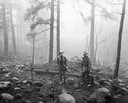
| Description: | Forest rangers look over charred ruins of timber in a forest where "Smokey," a black bear cub was found suffering from third degree burns. |

| Date: | |
|---|---|
| Description: | View of a winding path with metal handrails leading up the side of a mountain to a fire lookout tower. |
| Date: | |
|---|---|
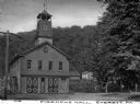
| Description: | Front view of the multi-story brick Fireman's Hall. A tower with a lookout at the top extends from the roof. A forested hill and dwellings appear in the ... |

| Date: | 1903 |
|---|---|
| Description: | Map shows location of government buildings, schools, churches, parks, and other points of interest. The upper left hand margin features a "Reference" secti... |

| Date: | 1900 |
|---|---|
| Description: | This map of Three Lakes shows forest fire lookout towers, picnic grounds, an airport, roads, and railroad. The map features text boxes on the Village of Th... |

| Date: | 06 1890 |
|---|---|
| Description: | This map shows building use, railroads, tramways, lumber yards, roads, watchman’s stations, and steam pipes. Also included is text about buildings, Clapp a... |
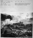
| Date: | 1950 |
|---|---|
| Description: | Elevated view of a man using a TD-18A to cover up a fire. Subject: "TD-18A — Land Clearing." Where Taken: "MtS." Information with photograph reads: "This ... |
If you didn't find the material you searched for, our Library Reference Staff can help.
Call our reference desk at 608-264-6535 or email us at: