 Filter: Categories of Wisconsin Historical Images
Filter: Subject of Fire extinction
Filter: Subject of recreation
Filter: Subject of human settlements
Filter: Categories of Wisconsin Historical Images
Filter: Subject of Fire extinction
Filter: Subject of recreation
Filter: Subject of human settlements
| Date: | |
|---|---|
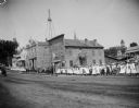
| Description: | Parade of women and children on sidewalk through town. They are going past Peter Olson's blacksmith shop (foreground), fire-bell tower, and the City Hall w... |

| Date: | 1968 |
|---|---|
| Description: | The map shows fire towers, public camp grounds, roads, snow mobile & riding trails, trout lakes, foot trails, railroads, and National Forest boundaries. |
| Date: | 08 1995 |
|---|---|
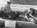
| Description: | "Les Beck was honored for being with the Theresa Fire Department for 60 years." |

| Date: | 1955 |
|---|---|
| Description: | This map shows roads, golf courses, airports, fire towers, schools, camp grounds, rivers, streams, lakes, and railroads. The right margin of the map includ... |

| Date: | 1940 |
|---|---|
| Description: | This map shows lakes, roads, car trails, foot trails, railroads, resorts and camps, and fire towers. The map includes an inset location map and pictorial d... |
If you didn't find the material you searched for, our Library Reference Staff can help.
Call our reference desk at 608-264-6535 or email us at: