 Filter: Categories of Wisconsin Historical Images
Filter: Subject of Fire extinction
Filter: Subject of recreation areas
Filter: Categories of Wisconsin Historical Images
Filter: Subject of Fire extinction
Filter: Subject of recreation areas

| Date: | 1896 |
|---|---|
| Description: | A portion of John B. Heim's map of the Water Works System of Madison showing the size of the third Wisconsin Capitol (228' x 226') in comparison with the C... |
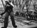
| Date: | 05 1984 |
|---|---|
| Description: | "MPTI instructors from Fond du Lac instructed over 200 firemen from 16 fire departments in the techniques of rappelling and snuffing out fires at Theresa F... |
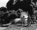
| Date: | 05 1984 |
|---|---|
| Description: | "MPTI instructors from Fond du Lac instructed over 200 firemen from 16 fire departments in the techniques of rappelling and snuffing out fires at Theresa F... |

| Date: | 1903 |
|---|---|
| Description: | Map shows location of government buildings, schools, churches, parks, and other points of interest. The upper left hand margin features a "Reference" secti... |
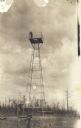
| Date: | 1913 |
|---|---|
| Description: | View towards tower, with a man standing on the platform on the top. This postcard has a handwritten notation on the back: "One of the first forest protecti... |
If you didn't find the material you searched for, our Library Reference Staff can help.
Call our reference desk at 608-264-6535 or email us at: