 Filter: Categories of Wisconsin Historical Images
Filter: Subject of Fire extinction
Filter: Subject of state parks and reserves
Filter: Categories of Wisconsin Historical Images
Filter: Subject of Fire extinction
Filter: Subject of state parks and reserves

| Date: | 1968 |
|---|---|
| Description: | The map shows fire towers, public camp grounds, roads, snow mobile & riding trails, trout lakes, foot trails, railroads, and National Forest boundaries. |

| Date: | 1937 |
|---|---|
| Description: | This map shows the Wisconsin Conservation Department forest protection divisions and the locations of state forests, national forests, Indian reservations,... |

| Date: | 05 01 1938 |
|---|---|
| Description: | This map shows the locations of Wisconsin Conservation Department forest protection districts and cooperative areas, state forests, national forests, India... |
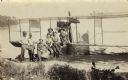
| Date: | 1915 |
|---|---|
| Description: | View from shoreline of Trout Lake of a group of six men posed with the pilot, possibly Jack Vilas, on an early seaplane or flying boat floating in the wate... |

| Date: | 1950 |
|---|---|
| Description: | Wisconsin Historical Marker near Trout Lake. The marker recognizes the first ever forest patrol flight. The marker text reads: "FIRST FOREST PATROL FLI... |
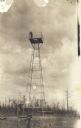
| Date: | 1913 |
|---|---|
| Description: | View towards tower, with a man standing on the platform on the top. This postcard has a handwritten notation on the back: "One of the first forest protecti... |
If you didn't find the material you searched for, our Library Reference Staff can help.
Call our reference desk at 608-264-6535 or email us at: