 Filter: Categories of Wisconsin Historical Images
Filter: Subject of Fire extinction
Filter: Subject of streets
Filter: Subject of water
Filter: Categories of Wisconsin Historical Images
Filter: Subject of Fire extinction
Filter: Subject of streets
Filter: Subject of water
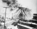
| Date: | 12 11 1926 |
|---|---|
| Description: | Fire destroyed the Atlas Flour Mill, causing an estimated $100,000 in damage. Thirteen engine companies, six truck companies, and two fire boats fought the... |
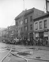
| Date: | 03 20 1935 |
|---|---|
| Description: | View across street towards the Madison Steam Laundry, at 433 State Street, the scene of a fire. In front of the building is a fire truck with extension lad... |

| Date: | 1896 |
|---|---|
| Description: | A portion of John B. Heim's map of the Water Works System of Madison showing the size of the third Wisconsin Capitol (228' x 226') in comparison with the C... |
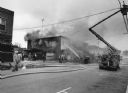
| Date: | 11 1991 |
|---|---|
| Description: | "With windchill factors below zero, firemen battled this fire at Das Pioneer Bier haus, operated by Mike Polster. Former proprietors were John Miller, Henr... |

| Date: | 1947 |
|---|---|
| Description: | Lower left hand corner features a legend. "Drawn 1938, revised 1947." Shows water mains, hydrants, corporation limits, city ward divisions, fire proof buil... |

| Date: | 1900 |
|---|---|
| Description: | This map of Three Lakes shows forest fire lookout towers, picnic grounds, an airport, roads, and railroad. The map features text boxes on the Village of Th... |

| Date: | 02 18 1996 |
|---|---|
| Description: | A stream of water shoots into the front entrance of the burning, smoking Hotel Washington. The crumpled hotel sign still hangs on the balcony. |

| Date: | 06 1890 |
|---|---|
| Description: | This map shows building use, railroads, tramways, lumber yards, roads, watchman’s stations, and steam pipes. Also included is text about buildings, Clapp a... |

| Date: | 04 1901 |
|---|---|
| Description: | A Sanborn map of Watertown, including an index and a key. |

| Date: | 1908 |
|---|---|
| Description: | A Sanborn fire map of Brodhead. Includes an inset at top right showing distances from P.O. |
If you didn't find the material you searched for, our Library Reference Staff can help.
Call our reference desk at 608-264-6535 or email us at: