 Filter: Categories of Wisconsin Historical Images
Filter: Subject of Fishing
Filter: Year of 1900-1999
Filter: Categories of Wisconsin Historical Images
Filter: Subject of Fishing
Filter: Year of 1900-1999
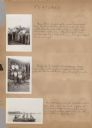
| Date: | 1942 |
|---|---|
| Description: | Page from a scrapbook kept by Neighborhood House, with highlights of the boys summer camp at Camp America Williams: "backwards" day, with a line of boys dr... |

| Date: | 1930 |
|---|---|
| Description: | View of a pile of fish on a stringer lying in the grass, these fish may have been caught on Lake Namakagon. A person's hand appears at the top, holding the... |
| Date: | 1938 |
|---|---|
| Description: | A man wearing a hat stands on the steps of the front porch of a cabin holding up a large fish at Cormican's on Clam Lake. |

| Date: | 1933 |
|---|---|
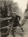
| Description: | View across water of a man fly fishing. He is standing in the Namakagon River in northwestern Wisconsin. Trees are along the shoreline on both sides of the... |

| Date: | 1930 |
|---|---|
| Description: | View of Alton Van Camp wearing a hat holding a huge record Muskie listed at "59 1/2 lb" caught by his friend Louie Spray. Caption reads: "Louie Spray's 59½... |
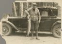
| Date: | 1933 |
|---|---|
| Description: | Outdoor portrait of a man wearing boots, pants, shirt, sweater and hat holding a large fish by its gills while standing in front of an automobile. |
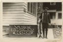
| Date: | 1935 |
|---|---|
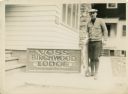
| Description: | Outdoor portrait of a man wearing boots, a jacket and hat holding a large fish next to a building and sign that says "Voss Birchwood Lodge, Strictly Modern... |
| Date: | 1936 |
|---|---|
| Description: | Outdoor portrait of a man wearing boots, a sweater and hat holding a large fish and standing next to a building and a sign that says "Voss Birchwood Lodge,... |

| Date: | 1935 |
|---|---|
| Description: | This pictorial map of northern Bayfield County, Wisconsin, shows the Chequamegon National Forest, the Red Cliff Indian Reservation, highways and roads, and... |
| Date: | 1935 |
|---|---|
| Description: | View from shoreline of men fishing out of wooden rowboats on the Flambeau River below the flowage dam. One man is standing in the river. A shack is visible... |

| Date: | 1915 |
|---|---|
| Description: | View along shoreline towards fishing nets drying on the rail of the pier at Dr. Gordon's cottage on North Bay. |

| Date: | 1915 |
|---|---|
| Description: | View from rocky shoreline of a man with a fishing pole standing in the shade provided by a small roof at the end of Dr. Gordon's pier. Fishing nets dry alo... |
| Date: | 1915 |
|---|---|
| Description: | View down hill towards a man fishing from the pier at Nelson Point in Peninsula State Park. Fish Creek is seen across the bay. Dr. Welcker's Casino is the ... |

| Date: | 1938 |
|---|---|
| Description: | This 1938 tourist map of Douglas County, Wisconsin, identifies game refuges, fishing locations, and other outdoor recreation opportunities in the county. A... |
| Date: | 1922 |
|---|---|
| Description: | In a publicity still used to promote "The World's Champion," the silent film star Wallace Reid is shown fishing in a river, probably in Yosemite National P... |

| Date: | 1921 |
|---|---|
| Description: | Gloria Swanson stands on a chair with a fishing net in her hand and a fishing basket around her neck as Wallace Reid holds out a flower in a scene still fr... |

| Date: | 1940 |
|---|---|
| Description: | Map shows hydrography and location of game fish in part of Vilas County, Wisconsin and Gogebic County, Michigan. |

| Date: | 1986 |
|---|---|
| Description: | This late 1980s map of Price County, Wisconsin, shows facilities and lands open for public recreation, hunter walking trails and ski trails, campgrounds, b... |

| Date: | 1976 |
|---|---|
| Description: | Panel title. Shows railroads, roads, highways, boundaries, dams, public hunting and fishing grounds, cemeteries, forest ranger stations, plant life, and s... |
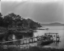
| Date: | 1926 |
|---|---|
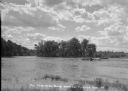
| Description: | Lake Wisconsin at Summerville Park. Boathouses, docks and fishing boats are along the shoreline. |
If you didn't find the material you searched for, our Library Reference Staff can help.
Call our reference desk at 608-264-6535 or email us at: