Filter: Categories of Wisconsin Historical Images
Filter: Subject of Floods
Filter: Year of 1900-1999
Filter: Categories of Wisconsin Historical Images
Filter: Subject of Floods
Filter: Year of 1900-1999

| Date: | 02 26 1948 |
|---|---|
| Description: | Flood at the University of Wisconsin-Madison East Hill Trailer Camp, located at 451 North Midvale Boulevard, south of University Avenue. Several men are sh... |

| Date: | 02 27 1947 |
|---|---|
| Description: | Flood at the University of Wisconsin-Madison East Hill Trailer Camp, located at 451 North Midvale Boulevard, south of University Avenue. Looking west, sho... |

| Date: | 07 20 1948 |
|---|---|
| Description: | View from nearby roof of flood damage which caused the collapse of the roof of the Lark Cocktail Lounge at 2554 University Avenue. |

| Date: | 07 20 1948 |
|---|---|
| Description: | Flood damage to the interior of Lark Cocktail Lounge at 2554 University Avenue. |

| Date: | 07 20 1948 |
|---|---|
| Description: | Flood damage, including a collapsed ceiling, to the interior of the Lark Cocktail Lounge at 2554 University Avenue. |
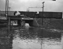
| Date: | 07 20 1948 |
|---|---|
| Description: | Flooded South Park Street underpass, with car stalled in three feet of water. A train is on the railroad bridge above. A young boy and girl wearing bathing... |
| Date: | 1917 |
|---|---|
| Description: | View looking across the river east into Black River Falls during the flood, showing the elevated level of the river and buildings falling into the water. C... |
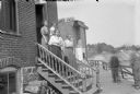
| Date: | 1911 |
|---|---|
| Description: | Four telephone operators pose on the steps of the Black River Falls Exchange Office Building. The second woman from the bottom is probably Mrs. W.E. (Hagen... |

| Date: | 1907 |
|---|---|
| Description: | Topographic map of the Wisconsin River done under direction of Daniel Meade for construction of the Kilbourn dam by the Southern Wisconsin Power Company. I... |

| Date: | 1926 |
|---|---|
| Description: | This hand-colored blueprint map shows landowners in part of T15N, R5E in Juneau County. North is oriented to the right. |
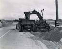
| Date: | 1941 |
|---|---|
| Description: | International TD-9 crawler tractor (TracTracTor) lifts dirt into a dump truck. Original caption reads: "An International TD-9 Diesel TracTracTor equipped w... |

| Date: | 03 05 1950 |
|---|---|
| Description: | Flooding along University Avenue at Shorewood Boulevard in front of Frenchy's restaurant, 3302 University Avenue. |

| Date: | 03 05 1950 |
|---|---|
| Description: | Flooding along University Avenue at Shorewood Boulevard. Businesses in the photograph include Frenchy's Restaurant, 3302 University Avenue, and the Walter ... |

| Date: | 04 27 1950 |
|---|---|
| Description: | View of damage to the breakwater behind the home of Dr. J.G. Frisch, 1653 Sherman Avenue, caused by high water and waves driven by strong winds. |
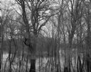
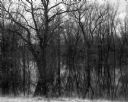
| Date: | 04 18 1965 |
|---|---|
| Description: | View of a wooded area affected by a Wisconsin River flood. |
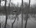
| Date: | 04 18 1965 |
|---|---|
| Description: | View through trees and over water of a small house in a wooded area surrounded by water due to the flooding of the Wisconsin River. |

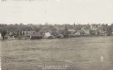
| Date: | 1925 |
|---|---|
| Description: | Elevated view of a small town with a river and bridge in the foreground. High water has washed away the road and river bank at the far end of the bridge. T... |

| Date: | 07 04 1960 |
|---|---|
| Description: | Landscape view of a flooded field at sunrise. |
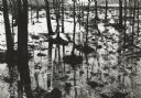
| Date: | 05 10 1960 |
|---|---|
| Description: | Grove of trees in a flooded area from a late snow melt. |
If you didn't find the material you searched for, our Library Reference Staff can help.
Call our reference desk at 608-264-6535 or email us at: