 Filter: Categories of Wisconsin Historical Images
Filter: Subject of Floods
Filter: Year of 1900-1999
Filter: Year of 1920-1929
Filter: Categories of Wisconsin Historical Images
Filter: Subject of Floods
Filter: Year of 1900-1999
Filter: Year of 1920-1929

| Date: | 1926 |
|---|---|
| Description: | This hand-colored blueprint map shows landowners in part of T15N, R5E in Juneau County. North is oriented to the right. |

| Date: | 1922 |
|---|---|
| Description: | View along steep shoreline towards people among the rubble near buildings at the top of the bank on the left. The river is on the right. Location identifie... |

| Date: | 04 30 1927 |
|---|---|
| Description: | View across water towards trees in the distance. There are clumps of hay or plants in the water, perhaps a flooded field. |

| Date: | 04 30 1927 |
|---|---|
| Description: | View across field flooded with water towards trees in the distance. There are clumps of hay or plants in the water. |

| Date: | 04 30 1927 |
|---|---|
| Description: | Clump of grain in a field, perhaps left by a flood. |
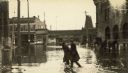
| Date: | 04 10 1922 |
|---|---|
| Description: | Two women are walking through floodwaters from the Oconto River. A horse-drawn carriage with its wheels halfway underwater is in the background near the Oc... |
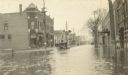
| Date: | 04 13 1922 |
|---|---|
| Description: | The car is plowing through flood waters on Main Street. Commercial buildings and telephone poles are in the background. |
If you didn't find the material you searched for, our Library Reference Staff can help.
Call our reference desk at 608-264-6535 or email us at: