 Filter: Categories of Wisconsin Historical Images
Filter: Subject of Foliage
Filter: Subject of ocean
Filter: Categories of Wisconsin Historical Images
Filter: Subject of Foliage
Filter: Subject of ocean
| Date: | |
|---|---|
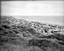
| Description: | Tents line a beach along the Atlantic Ocean. Foliage covers the foreground and several people and vehicles can be seen throughout the camp. |

| Date: | |
|---|---|
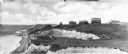
| Description: | A rocky coast is populated with homes, hotels, and a lighthouse. |
| Date: | |
|---|---|
| Description: | Homes stand along the coast near cliffs on Block Island. |
| Date: | |
|---|---|
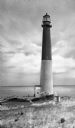
| Description: | Barnegat Lighthouse was built in 1854 by the U.S. government. Oil-powered lights were originally installed in 1856 but were replaced by electric lights in ... |
| Date: | 01 02 1944 |
|---|---|
| Description: | At 8:30 am, military vehicles pour off of the LST (Landing Ship, Tank) and along the beach at Saidor, New Guinea (present day Papua New Guinea). Doyle's ca... |
| Date: | 02 28 1945 |
|---|---|
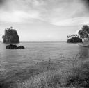
| Description: | Robert Doyle notes, "Strange island near Pago Pago." He was on Tutuila Island, in American Samoa, in the South Pacific. Palm trees are growing on the shore... |
| Date: | 1942 |
|---|---|
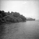
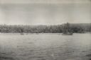
| Description: | View over water towards the New Guinea coast from a boat. A larger boat is on the right and several smaller craft in the center. A pier is on the shoreline... |

| Date: | 1720 |
|---|---|
| Description: | Double hemispherical world map showing routes of Tasman, Magellan, Mendana, etc. Relief shown pictorially. Title in oak wreath cartouche. Map between four ... |

| Date: | 1746 |
|---|---|
| Description: | A map of the western hemisphere, including parts of western Europe and Africa, showing the division of the Americas by the European powers. Weapons and fol... |
If you didn't find the material you searched for, our Library Reference Staff can help.
Call our reference desk at 608-264-6535 or email us at: