 Filter: Categories of Wisconsin Historical Images
Filter: Subject of Food industry and trade
Filter: Year of 1800-1899
Filter: County of Jefferson
Filter: Categories of Wisconsin Historical Images
Filter: Subject of Food industry and trade
Filter: Year of 1800-1899
Filter: County of Jefferson
| Date: | 1885 |
|---|---|
| Description: | View of the Rockdale mill, a grist and sawmill built in 1847 by Thomas and Nathan Van Horn. A group of people are standing on a sidewalk or loading dock on... |

| Date: | 1890 |
|---|---|
| Description: | Dining room decorated with streamers for a wedding reception. The table is set formally with candles and there is a wedding cake as a centerpiece. |

| Date: | 1860 |
|---|---|
| Description: | View of the Rock River with a train on a railroad bridge in the foreground, and the town in the distance. Pedestrians are walking along a path on the left ... |
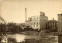
| Date: | 1890 |
|---|---|
| Description: | View across water towards the Empire Mill. Alongside the building are railroad cars at a loading dock. The signs on the mill read: "Globe", "Globe's Empire... |

| Date: | 09 1884 |
|---|---|
| Description: | Sanborn map of Fort Atkinson including Barrie, Germany, and North Water Streets. |
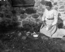
| Date: | 1899 |
|---|---|
| Description: | Sarah Krueger Bhend feeding kittens in front of a farm building. |
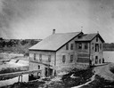
| Date: | 05 1899 |
|---|---|
| Description: | View of William Krueger's house across the road from the Krueger farm. |

| Date: | 1896 |
|---|---|
| Description: | A hand-colored Map of Jefferson County, Wisconsin, shows township and section divisions, towns, villages and post offices, rural residents, railroads, road... |

| Date: | 10 1884 |
|---|---|
| Description: | A Sanborn map of Watertown, including the City Brewery and the Rock River. |
If you didn't find the material you searched for, our Library Reference Staff can help.
Call our reference desk at 608-264-6535 or email us at: