 Filter: Categories of Wisconsin Historical Images
Filter: Subject of Forests and forestry
Filter: Year of 1900-1999
Filter: County of Dane
Filter: Categories of Wisconsin Historical Images
Filter: Subject of Forests and forestry
Filter: Year of 1900-1999
Filter: County of Dane
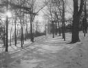
| Date: | 1925 |
|---|---|
| Description: | Winter scene of trees on a snowy hill along University Drive. There is a building at the top of the hill obscured by trees. |
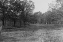
| Date: | 1930 |
|---|---|
| Description: | View of a wide path through trees in the spring or summer. |
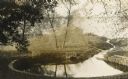
| Date: | 1910 |
|---|---|
| Description: | Big spring on Lake Mendota Drive. [Merrill Springs or sometimes Merrill's Spring] |
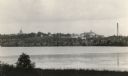
| Date: | 1915 |
|---|---|
| Description: | The University of Wisconsin from Picnic Point. Buildings that can be seen are Bascom Hall with dome, the Students' Observatory, Washburn Observatory, the D... |

| Date: | 03 24 1913 |
|---|---|
| Description: | Picnic Point from the University Farm fields, now known as Observatory Hill. |

| Date: | 1930 |
|---|---|
| Description: | Aerial view of Hoyt Park including the surrounding neighborhoods. Resurrection Cemetery can be seen at the upper right of the image. |

| Date: | 1930 |
|---|---|
| Description: | Aerial view of the University of Wisconsin-Madison Arboretum including a portion of Lake Wingra and surrounding residential neighborhoods. |

| Date: | 1930 |
|---|---|
| Description: | Aerial view of the University of Wisconsin-Madison Arboretum including the surrounding residential neighborhoods. |

| Date: | 11 16 1949 |
|---|---|
| Description: | Orrie Kreger, who is in charge of trees and grounds at the Poynette game farm, shows some charts to three honorary members of his Twin Pines Tree Clinic, a... |

| Date: | 05 24 1964 |
|---|---|
| Description: | View of tree tops, as seen from below. Sunlight falls on the top of the tree canopy. |

| Date: | 07 03 1965 |
|---|---|
| Description: | Close-up view of fallen oak tree branches. Leaves of other trees can be seen in the background. |
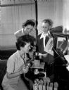
| Date: | 10 11 1950 |
|---|---|
| Description: | Three women employees of Forest Products Laboratory and members of the Madison Business and Professional Women's Club, pose around a microscope. The club i... |
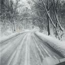
| Date: | 1960 |
|---|---|
| Description: | A winter scene down a road in the snow-covered arboretum. |

| Date: | 07 15 1958 |
|---|---|
| Description: | Aerial view of Eagle Heights Farm, Eagle Heights Woods and part of Lake Mendota. Sites labeled on the image are Eagle Heights, Tent Colony, Apartment Site,... |

| Date: | 1970 |
|---|---|
| Description: | Color coded map. Legend in the top left hand corner reads: "EXISTING AIRPORT PAVEMENT" (purple), "FUTURE 5-YEAR DEVELOPMENT" (bright pink), "ULTIMATE AIRPO... |

| Date: | 01 25 1959 |
|---|---|
| Description: | Winter scene with brothers Greg and Mark Hennen of 5709 Midmoor Road standing in their snow fort and holding snowballs at the ready the day following a fiv... |

| Date: | 1960 |
|---|---|
| Description: | Hardwood growth in the Madison School Forest. |

| Date: | 05 23 1961 |
|---|---|
| Description: | Spring birch forest from Katzenbeuchel Road. |

| Date: | 05 28 1964 |
|---|---|
| Description: | Outdoor portrait of Jim Zimmerman, the school forester, standing in a field. |

| Date: | 01 13 1937 |
|---|---|
| Description: | Sketch map of Township 7 North, Range 9 East, created for the Land Economic Inventory (Bordner Survey). The map shows Picnic Point and the Lake Mendota sho... |
If you didn't find the material you searched for, our Library Reference Staff can help.
Call our reference desk at 608-264-6535 or email us at: