 Filter: Categories of Wisconsin Historical Images
Filter: Subject of Forests and forestry
Filter: Year of 1900-1999
Filter: Categories of Wisconsin Historical Images
Filter: Subject of Forests and forestry
Filter: Year of 1900-1999
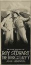
| Date: | 1918 |
|---|---|
| Description: | Movie poster using a heavily retouched film still for "The Boss of the Lazy 'Y,'" a western. Shown on the right is actor Roy Stewart, playing Calumet Marst... |

| Date: | 1911 |
|---|---|
| Description: | View down an unpaved road towards a four-story mill. Two boys pose on the side of the road. |

| Date: | 1902 |
|---|---|
| Description: | Stand of pine trees with ground covered in pine cones and needles. |

| Date: | 08 1922 |
|---|---|
| Description: | This Wisconsin State Conservation Commission map shows the distribution of standing timber per township. The northern tier of counties is covered, as are V... |

| Date: | 04 1932 |
|---|---|
| Description: | This Wisconsin Conservation Department map shows federal, state, and county forest areas, the relative proportion of land owned by each agency, and state p... |

| Date: | 06 1934 |
|---|---|
| Description: | This Wisconsin Conservation Department map shows national, state, and county forests both approved and pending, as well as Indian reservations in Wisconsin... |

| Date: | 1935 |
|---|---|
| Description: | This three-part map from the U.S. Bureau of Public Roads identifies highways in Wisconsin that have been improved, indicating those which are federal highw... |

| Date: | 05 1935 |
|---|---|
| Description: | This Wisconsin Conservation Department map shows the locations of state forests, state nurseries, state parks, roadside parks, prison camps, and lookout to... |

| Date: | 1935 |
|---|---|
| Description: | "Drott's conservation guide" map shows the locations of Indian reservations, parks, fish hatcheries, forests, lookout towers, Wisconsin Conservations Commi... |

| Date: | 1936 |
|---|---|
| Description: | This 1936 Wisconsin Conservation Dept. map shows the locations of state forestry Civilian Conservation Corps (CCC) camps, closed state forestry CCC camps, ... |

| Date: | 05 01 1938 |
|---|---|
| Description: | This map shows the locations of Wisconsin Conservation Department forest protection districts and cooperative areas, state forests, national forests, India... |

| Date: | 1939 |
|---|---|
| Description: | This nine-part map from the U.S. Bureau of Public Roads identifies federal and state highways in Wisconsin by pavement type. County, forest, park, and publ... |

| Date: | 1944 |
|---|---|
| Description: | This nine-part map from the U.S. Bureau of Public Roads identifies federal and state highways in Wisconsin by pavement type. County, forest, park, and publ... |
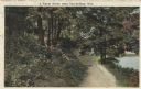
| Date: | 08 1917 |
|---|---|
| Description: | Colorized postcard of a rural scene. A dirt path winds through the forest, and a pond or stream can be seen in the lower right corner. Text above reads: "A... |

| Date: | 1906 |
|---|---|
| Description: | A hand-colored commercial map of Wisconsin and portions of eastern Minnesota, Iowa, northern Illinois, and the Michigan’s Upper Peninsula. The map shows ra... |
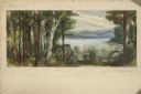
| Date: | 1948 |
|---|---|
| Description: | Prior to the 1948 State Fair, artist Robert Hodgell traveled Wisconsin to study its many landscapes. He then produced a series of study sketches outlining ... |

| Date: | 1920 |
|---|---|
| Description: | This early 1920s map shows state-owned land in townships 38 and 39, range 7 east, the towns of Lake Tomahawk and Woodruff, in Oneida County, Wisconsin, tha... |

| Date: | 1959 |
|---|---|
| Description: | This map identifies public forest land and industrial forest land as of 1959 in Oneida County, Wisconsin, using a 1930 base map showing the township and ra... |

| Date: | 1956 |
|---|---|
| Description: | This map shows the types of upland and lowland forest vegetation on Stockton Island, one of the Apostle Islands in Lake Superior. |

| Date: | 1930 |
|---|---|
| Description: | Aerial view, looking northeast, across Mud Lake with North Bay in the background, showing cultivated fields and wooded land. |
If you didn't find the material you searched for, our Library Reference Staff can help.
Call our reference desk at 608-264-6535 or email us at: